
 We were delighted in 2004 when the Highways Agency agreed to fund our suggestion that the spare archway under the A41, next to the M1, be used to carry walkers, riders and cyclists from one side of the A41 to the other.
We had hoped to have an official opening of the path in time for the BHS Access Week in May. Although the physical work had been completed by then, the Highways Agency needed ministerial approval for an order removing motorway regulations from the land. It had legally been part of the motorway and hence was subject to the usual rules prohibiting pedestrians and animals, and specifying minimum speeds!
The crossing joins Bushey 68 (the bridleway near Tyler’s Farm) to Bushey 36 (which leads to Hilfield Lane), and will be the first brand new crossing for the H25 in Hertfordshire. It will open as soon as the appropriate statutory instrument is made.
 The Trust was delighted in August when work started to create a Pegasus (light-controlled) crossing of Bell Lane. The H25 London Orbital Bridleroute comes over the M25 on paths London Colney 1 and Shenley 35 before crossing Bell Lane to become Shenley 21 by the Arsenal training ground. Bell Lane is used by motorists almost as a slip road to the M25, and the new crossing makes it much safer for riders, walkers and cyclists when crossing the road.
 We were pleased to announce our second 'current major project' (CMP2) for a network of paths in the Aldenham village area. There are opportunities here that could be realised with the goodwill and help of the Hertfordshire County Council Rural Estates Department and the developers of the former University of Hertfordshire site.
Image based on original obtained from the Ordnance Survey Get-a-map service (2005). Image reproduced with kind permission of Ordnance Survey.
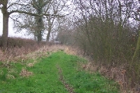 The objections to the order to record Tykeswater Lane, which joins Butterfly Lane and Watling Street to Theobald Street, were withdrawn prior to an inquiry and so the order was confirmed. Within days, the County Council made a temporary traffic regulation order, to enable it to remove the illegal obstructions and check whether surfacing work was needed.
We were surprised in September when the County Council’s development control committee considered a resolution which, if passed, would have made it an offence for the route to be used by riders and cyclists. Late night lobbying by the Trust, the BHS and BADFA resulted in a change to the motion, and the final regulation order only prohibits motor vehicle use. A further temporary order prohibits equestrians and cyclists until some safety works at each end of the path have been performed.
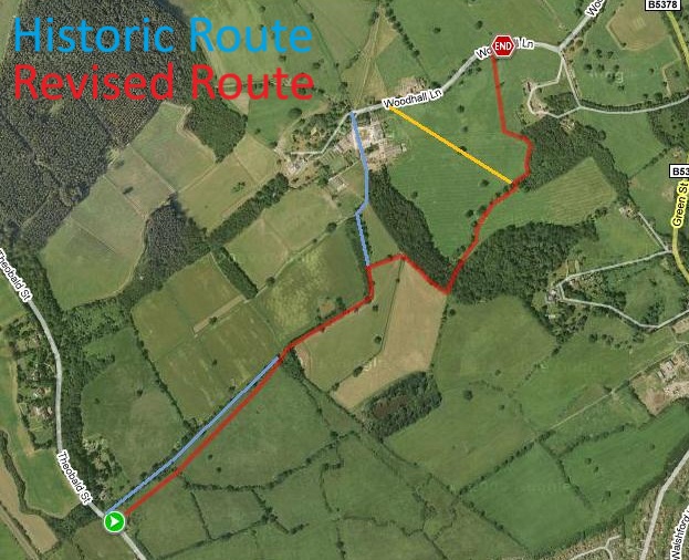 The application for Woodhall Lane (shown blue on the plan), which joins Theobald Street and Tykeswater Lane to Shenley, resulted in an order being made in July 2005. There were objections and so a public inquiry will need to be held.

 We continued the verge campaign to retain the rights of riders where this sign is put up.
Following the passage of the Traffic Management Act 2004, the Trust found that it would become possible for a rider to get a ticket for riding a verge that had these signs, as reported in the 2004 Annual Report. Following an intervention by the local MP, the Trust is now on the list of those to be consulted before the relevant section of the Act is brought into force.
The British Horse Society HQ took legal advice, and was advised that it is not an offence to disobey the blue and white traffic signs. The Society met senior civil servants in December 2005, and they agreed the advice in the Highway Code was wrong.
Locally, we await the revised promised signage on the Swanland Road (Potters Bar) verge. The Trust continues to press the Government for a review of signage for paths in the verge to clear up any confusion.

 The Patchetts Green Bridleways Trust has been recognised as having charitable status by the Charity Commission. The Trust was added to the Register of Charities on 17 May 2005 with charity number 1109497.

The Hertfordshire County Council Merryhill Greenway (Bushey 17 & 65, Watford Rural 12 & 31) Legal Event Modification Order 2005 added the bridleway dedicated by the Merry Hill Public Path Creation Agreement 2000 to the definitive map and statement.
The Hertfordshire County Council (Dyes Lane, Langley 21/Knebworth 43) Modification Order 2004, made 23 Jul 2004, proposes to add this route as a byway to the definitive map and statement.
The Hertfordshire County Council (Cheshunt 17, 70, 73, 74, 75 and Enfield 002) Modification Order 2005, made 22 Dec 2005, proposes to add or upgrade various paths to the definitive map and statement.

© 2025 Patchetts Green Bridleways Trust.
