Legal History
2 Feb 1953: Cheshunt 17 was shown as a footpath on the original definitive map and statement for Hertfordshire.
DM sheet DM2-36 (Herts 41 NW).
2 Feb 1953: Cheshunt 70 was not shown on the original definitive map and statement for Hertfordshire.
DM sheets DM2-36 (Herts 41 NW) and DM2-38 (Herts 41 SW).
1 Aug 1953: Enfield 2 was shown as a Road Used as a Public Path on the draft map for Middlesex.
Map sheet Middx 2 SW (Herts 41 SW).
31 Dec 1974: Enfield 2 was shown as a bridleway in the review map and statement for LB Enfield. Map Sheet: Middx 2.br>
31 Dec 1977: Cheshunt 17 and Cheshunt 70 were shown as footpaths on the special review draft map and statement for Hertfordshire.
DM sheet SR-80 (TL30SW).
11 Sep 1981: London Gazette announcement of confirmation of The Borough of Broxbourne (Burnt Farm Ride) Public Footpath Creation Order 1980 which 'created' Cheshunt 70 FP.
1999: EHFS application for several routes including Theobalds Lane (HCC reference BRX/27)
The Hertfordshire
County Council (Cheshunt 17, 70, 73, 74, 75 and Enfield 002) Modification
Order 2005 (confirmed 26 Aug 2008) added Cheshunt 70 BW to, and upgraded Cheshunt 17 FP to BW, on the definitive map and statement.
|
Definitive Statement (4 Dec 2015)
Path: [Cheshunt] 17. Status: Bridleway.
Definitive Map sheet: 80
Commences at junction with FP59 at TL 3157 0152 thence north to junction with Jones
Road at TL 3159 0206.
Width: Varying from 8 to 12 metres between TL 3157 0152 and TL 3159 0206 by
reference to the area uncoloured in the 1910 Finance Act map. Hertfordshire
County Council (Cheshunt 17, 70, 73, 74, 75 and Enfield 002) Modification
Order 2005
Limitations: None
Path: [Cheshunt] 70. Status: Bridleway.
Definitive Map sheets: 80, 81
Commences at the junction of FP 59, BR 17 and BR 73 at TL 3157 0512, thence southwards
to the County Boundary on the north side of the M25 at TL 3154 0084.
Width: Varying from 6 to 11 metres between TL 3157 0152 and TL 3154 0084 by
reference to the area uncoloured in the 1910 Finance Act map. Hertfordshire
County Council (Cheshunt 17, 70, 73, 74, 75 and Enfield 002) Modification
Order 2005
Limitations: None
Definitive Statement (28 Nov 2020)
Path: [L.B.Enfield] 2. Status: Bridleway.
Commences at the borough boundary immediately to the north of the M25
motorway. Proceeds southwards through motorway underpass and continues
south passing Glasgow Stud Farm on east side then cottages on west side.
Path ends at Sanders Corner at Cattlegate Road by junction with Theobalds
Park Road.
Width: Varying from 6 to 11 metres between TL 3157 0152 and TL 3154 0084 by
reference to the area uncoloured in the 1910 Finace Act map. Hertfordshire
County Council (Cheshunt 17, 70, 73, 74, 75 and Enfield 002) Modification
Order 2005
Limitations: None
Enfield's published statement does not include the text in red above added by the HCC order.
|
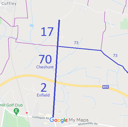
 This route was recorded following the application of the East Herts Footpaths Society. The County Council's order attracted objections. The EHFS led at the inquiry and the order was confirmed, adding a whole network of paths in the vicinity.
