
Annotated map reproduced courtesy of Googlemaps.
At the time of the 2023 Access Survey (10 Dec 23), the route was unobstructed and open to use. There was no signage.
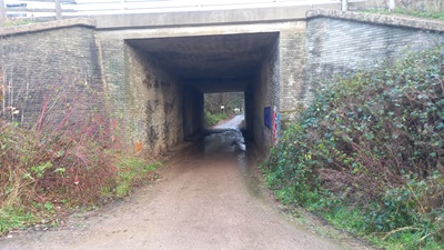
Under the A1(M) Motorway
Photo: Phil Wadey, 10 Dec 2023
| Paths Greenways Bridleways Tracks | ||
| PG: OBJECTS: PROMOTION: Stevenage: Meadway (public road) | ||
| Stevenage Horse and Pony Route: Anti-clockwise: Kitchin Lane. Clockwise (Phase 2 route): Meadway to Symmonds Green Lane OR Clockwise (Phase 1 route): former Symmonds Green Lane. | SHPR | |
Annotated map reproduced courtesy of Googlemaps. |
This section of the Stevenage Horse and Pony Route starts from Kitching Lane and passes under the A1(M) motorway. It continues generally eastwards as a public road to a junction with the Stevenage Horse and Pony Route (Phase 2 route) and then continues eastwards (to a junction with a historic route southwards) then northwards to the Stevenage Horse and Pony Route (Phase 1 route). The Phase 1 route is preferred when the phase 2 route could be wet and become poached.
At the time of the 2023 Access Survey (10 Dec 23), the route was unobstructed and open to use. There was no signage. |
Under the A1(M) Motorway Photo: Phil Wadey, 10 Dec 2023 |
||
| Legal History 1983: The route is shown in Stevenage Borough Council leaflet as part of Phase 1 SHPR which is stated as being open for use. 8 Dec 2004: This route is described as part of the existing Stevenage Horse and Pony Route on the Stevenage Local Plan map. | |
|
Location Information
Postcode for SATNAV for anyone inspecting path: SG1 2EN. |
© 2023 Patchetts Green Bridleways Trust.
