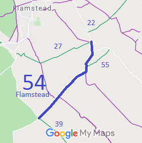
Annotated map reproduced courtesy of Googlemaps.
We need a volunteer to photograph this route for this year's Access and Riding Rights of Way Survey. It's easy - just take photographs (safely) when you use the path. Find out more!
| Paths Greenways Bridleways Tracks | ||
| PG: OBJECTS: PROMOTION: Flamstead 54 | ||
Annotated map reproduced courtesy of Googlemaps. |
This route starts at the corner of Green Lane (public road) and Flamstead 39 bridleway and runs generally northeastwards through junctions with
Flamstead 55 bridleway and
Flamstead 27 bridleway to a junction with Delmerend Lane (public road).
We need a volunteer to photograph this route for this year's Access and Riding Rights of Way Survey. It's easy - just take photographs (safely) when you use the path. Find out more! |
| Legal History 1838: Flamstead 54 is shown on the Flamstead tithe map as plot 1136, listed under 'roads and wastes' and with no apportionment assessed. 20 Jun 1953: The route was not recorded on the original definitive map and statement. DM sheet DM3-13. 31 Dec 1977: Part of the route was shown as footpath 52 on the special review draft map and statement. Objections were made. DM sheet SR-54. Unresolved Special Review cases had to be investigated under the WCA81 processes. HCC reference: DAC/44. The Hertfordshire County Council (Flamstead 54 and Flamstead 55) Modification Order 1996 added this route to the definitive map and statement. |
Definitive Statement (4 Dec 2015)
Path: [Flamstead] 54. Status: Bridleway. Definitive Map sheets: 54 Comences at junction with BR39 and County Road Green Lane (TL 0796 1312), thence NE for a distance of approx. 780m to junction with Redbourn 7 FP (TL 0849 1366), thence N for a distance of approx. 70m to junction with BR 55 (TL 0850 1373), thence in a generally northern direction for a distance of 320m to junction with FP 26 (TL 0853 1401) and with BR 27 (TL 0852 1402), thence NE for a distance of approx. 20m to junction with County Road Delmerend Lane (TL 0854 1404). Width: 4m-22m as shown hatched on the Order Plan forming part of the Hertfordshire County Council (Flamstead 54 and Flamstead 55) Modification Order 1996 Limitations: None |
© 2023 Patchetts Green Bridleways Trust.
File reference: EC019
