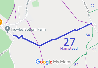
Annotated map reproduced courtesy of Googlemaps.
We need a volunteer to photograph this route for the 2021 Access and Riding Rights of Way Survey. It's easy - just take photographs (safely) when you use the path. Find out more!
| Paths Greenways Bridleways Tracks | ||
| PG: OBJECTS: PROMOTION: Flamstead 27 | ||
Annotated map reproduced courtesy of Googlemaps. |
This route runs from Trowley Farm Lane to Delmerend Lane.
We need a volunteer to photograph this route for the 2021 Access and Riding Rights of Way Survey. It's easy - just take photographs (safely) when you use the path. Find out more! |
| Legal History 20 Jun 1953: Flamstead 27 was recorded as a bridleway only between FP 26 and FP 27 on the original definitive map and statement. DM sheet DM3-13. 31 Dec 1977: Flamstead 27 was recorded as a bridleway on the special review draft map and statement from FP 26 to Trowley Farm Lane. DM sheet SR-54. Note: there is a kink in the path added at Special Review which looks unexpected. May be worth investigating. HCC reference DAC/107. |
Definitive Statement (4 Dec 2015)
Path: [Flamstead] 27. Status: Bridleway. Definitive Map sheet: 54 Commences from Trowley Farm Lane on the southern side of cottages, then runs between cottage gardens and farm buildings, to field opening, thence runs generally south eastwards following farm track, crosses FP48, then continues slightly NE crosses FP26 at Delmerend Lane. Width: 8 ft - 10ft |
© 2021 Patchetts Green Bridleways Trust.
File reference: EC583.
