Legal History
1 Nov 1953: Weston 1 was recorded as part bridleway part footpath on the original definitive map and statement. DM sheet DM4-18 and DM4-21.
31 Dec 1977: Weston 1 was shown as part bridleway part footpath on the special review (1977) draft map and statement. DM sheet SR-13.
12 Mar 2010: The Hertfordshire County Council (A505 Baldock Bypass) Legal Event Modification Order 2010 modified the definitive map and statement to show the changes made for the A505 bypass construction.
|
Definitive Statement (4 Dec 2015)
Path: [Weston] 1. Recorded Status: FP/BW.
Definitive Map sheet: 13
Commences from parish boundary at junction with FP23 and BR22 (Baldock Town) S of
Chalk Pit thence SE over A505 (Baldock Bypass) bridge crossing to a junction with BR48 at TL 2549 3296 and continuing past FP41 to junction with BR38 as a BR, thence SE as FP to join BOAT 39 at parish boundary NW of Ashanger Hill.
Width: 3 metres between TL 2542 3299 and TL 2548 3296
Limitations: None between TL 2542 3299 and TL 2548 3296
Path: [Clothall] 6. Recorded Status: FP.
Definitive Map sheet: 13
Commences from BR5 NW of St Mary's Church thence NW to parish boundary at junction
with BOAT 12.
|
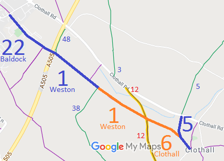
 As part of the British Horse Society's work to record paths before
Path Extinguishment Day,
it was spotted that the orange route is not fully recorded on the definitive map of rights of way, so we need to collect user statements to make an application.
