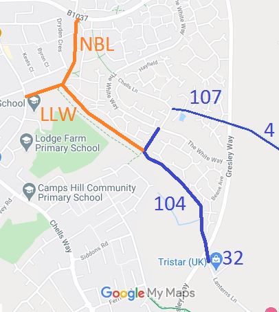
Annotated map reproduced courtesy of Googlemaps.
We need a volunteer to photograph this route for this year's Access and Riding Rights of Way Survey. It's easy - just take photographs (safely) when you use the path. Find out more!
| Paths Greenways Bridleways Tracks | ||||
| PG: OBJECTS: PROMOTION: Stevenage Lanterns Lane (West) | SHPR | |||
| Stevenage Horse and Pony Route: Anti-clockwise: (Page to be created). Clockwise: Stevenage 104. | ||||
Annotated map reproduced courtesy of Googlemaps. |
Lanterns Lane starts at Mobbsbury Way, heads generally NE to Narrow Box Lane then continues SE to a junction with Stevenage 104 bridleway.
We need a volunteer to photograph this route for this year's Access and Riding Rights of Way Survey. It's easy - just take photographs (safely) when you use the path. Find out more! |
| Legal History 1 Sep 1985: Lanterns Lane (East) stopped up reserving bridleway rights by Stevenage Magistrates Court. 13 Dec 2002: The Hertfordshire County Council (Stevenage 104 and Aston 32) Legal Event Modification Order 2002 added Lanterns Lane (East) to the definitive map as a bridleway. 20 Sep 2020: Application STEV/43 to record Lanterns Lane (West) as byway. 21 Sep 2020: Application STEV/44 to record Narrow Box Lane as byway. |
Definitive Statement (4 Dec 2015)
Path: [Stevenage] 104. Status: BW. Definitive Map sheets: 22 & 30 Lanterns Lane. Commences from The White Way approx. 20m east of Harvest Lane (TL 2660 2517) then runs SW for approx. 115m to TL 2654 2506 then runs SE for approx. 520m through the subway under the Gresley Way to the parish boundary at TL 2682 2464. Continues as Aston 32. Limitations: None. Path: [Aston] 32. Status: BW.
Definitive Map sheet: 30 |
© 2022 Patchetts Green Bridleways Trust.
File reference: EC414W.
