Legal History
1938: Pirton 5 is shown as part of Pirton 2 FP (red dots) on the Hertfordshire County Council ROW survey.
Map Hitchin Rural West 4 (Herts 6 SE).
1 Nov 1953: Pirton 5 was recorded as a footpath on the original definitive map and statement. DM sheet DM4-17.
1 Nov 1953: The unrecorded route south of Hitchin 1 RB was recorded as Hitchin 21 bridleway on the original definitive map and statement. DM sheet DM4-17.
19 Apr 1955: The section of Hitchin 21 south of Burford way was stopped up by The Stopping up of Highways (Hertfordshire) (No. 1) Order 1955.
31 Dec 1977: The relevant section of Pirton 5 was shown as a footpath on the special review draft map and statement. DM sheet SR-11.
31 Dec 1977: Hitchin 1 was shown as a bridleway on the special review draft map and statement, but there must have been objections as no change was made. DM sheet SR-11.
31 Dec 1977: Hitchin 21 was shown as a bridleway but with a shorter extent on the special review draft map and statement. DM sheet SR-11.
2 May 2006: Restricted Byway rights were confirmed or created on Hitchin 1 by virtue of ss 47 and 48 Countryside and Rights of Way Act 2000.
24 Mar 2013: Application made to record the whole route as a restricted byway.
HCC reference NH/246.
|
Definitive Statement (4 Dec 2015)
Path: [Pirton] 5. Status: Footpath.
Definitive Map sheets: 10, 11
Commences from Walnut Tree Road between Nos. 11 and 13 thence E and SE across Bannisters thence E between allotments and recreation ground thence SE and E to join SW side of Mill Way thence SE along inside of field across Icknield Way to join Restricted Byway 1 (Hitchin Town) at River Oughton.
Path: [Hitchin] 1. Status: Restricted Byway.
Definitive Map sheets: 11, 20
Commences from Bedford Road on S side of Burford Ray Bridge thence SW following River Oughton on S bank past BR21 at West Mill and FP2 to join Restricted Byway 3 at Oughton Head.
Path: [Hitchin] 21. Status: Bridleway.
Definitive Map sheets: 11, 20
Commences from Restricted Byway 1 S of West Mill thence SE to junction with Burford Way.
|
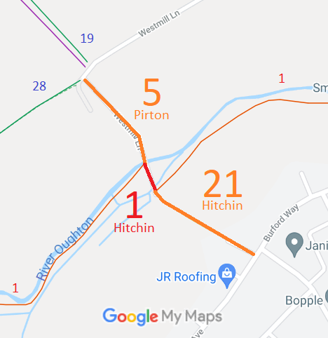
 As part of the British Horse Society's work to record paths before
Path Extinguishment Day,
it was spotted that part of this route is recorded as a footpath and part is unrecorded. The historical evidence showed a continuous route, so an application was made in 2013 to record the whole route correctly.