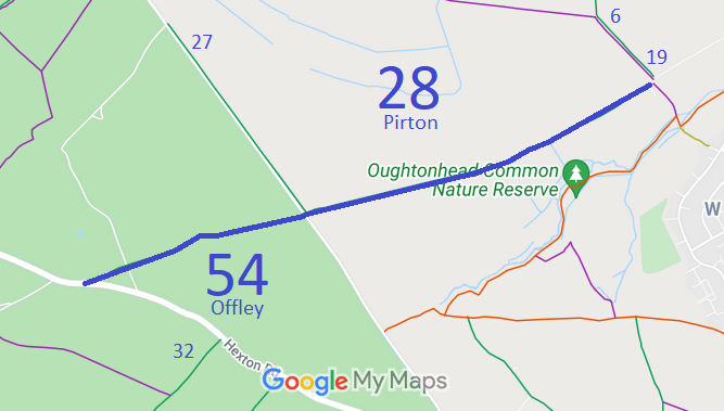
Annotated map reproduced courtesy of Googlemaps.
We need a volunteer to photograph this route for this year's Access and Riding Rights of Way Survey. It's easy - just take photographs (safely) when you use the path. Find out more!
| Paths Greenways Bridleways Tracks | ||
| PG: OBJECTS: PROMOTION: Pirton 28 and Offley 54 Icknield Way | IWRR | |
Annotated map reproduced courtesy of Googlemaps. |
This route is part of the Icknield Way.
We need a volunteer to photograph this route for this year's Access and Riding Rights of Way Survey. It's easy - just take photographs (safely) when you use the path. Find out more! |
| Legal History 1938: The Pirton part of route is shown as a green lane (green dots) on the Hertfordshire County Council ROW survey. The Offley part of the route is not shown. Map Hitchin Rural West 4 (Herts 6 SE). 28 Oct 2011: The Hertfordshire County Council (Offley 54 and Pirton 28) Modification Order 2011 (confirmed 14 Jan 2014) added this route to the definitive map and statement. |
Definitive Statement (4 Dec 2015)
Path: [Pirton] 28. Status: Bridleway. Definitive Map sheets: 10, 11, 19 Icknield Way commencing at the Hexton Road (a public road) at TL 1458 2996 and continuing generally NE along a track for approx. 1,000m to the junction with the Hitchin Road (a public road) at Punch s Cross at TL 1552 3028. Recommences on E side of the Hitchin Road at TL 1552 3028, past the junction with Pirton BR 27 at TL 1553 3029 and continues generally NE along a track (past the S turn of the parish boundary at TL 1561 3030) for approx. 1,625m to the parish boundary and junction with Westmill Lane (a public road) at TL 1702 3088. Width: Varies between 3m and 16m between TL 1458 2996 and TL 1561 3030 being the Pirton moiety of the route as shown shaded grey on the Plans forming part of the Hertfordshire County Council (Offley 54 and Pirton 28) Modification Order 2011 Varies between 9m and 20m between TL 1561 3030 and TL 1702 3088 as shown shaded grey on the Plans forming part of the Hertfordshire County Council (Offley 54 and Pirton 28) Modification Order 2011 Limitations: None Path: [Offley] 54. Status: Bridleway.
Definitive Map sheets: 10, 11, 19 |
© 2024 Patchetts Green Bridleways Trust. File reference: EC230.