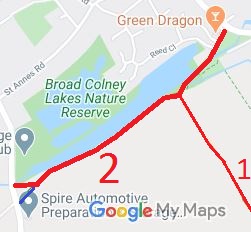
Annotated map reproduced courtesy of Googlemaps.
| Patchetts Green Bridleways Trust | ||
| PG: OBJECTS: PROMOTION: London Colney 2 RB Watery Lane | ||
| London Orbital Bridleroute: Anti-clockwise: London Colney 4. Clockwise: Shenley Lane to London Colney 1. | H25 | |
Annotated map reproduced courtesy of Googlemaps. |
This path runs from Shenley Lane generally eastwards to bridleway London Colney 37 thence generally eastwards to restricted byway London Colney 1 thence over the river to the village green and to Barnet Road. |
| Legal History 20 Jun 1953: London Colney 2 was recorded as CRB (Carriage Road used as a Bridleway) on the original definitive map and statement. DM sheet DM3-31 (TL10SE). 2 May 2006: Restricted Byway rights were confirmed or created on London Colney 2 by virtue of ss 47 and 48 Countryside and Rights of Way Act 2000. |
Definitive Statement (4 Dec 2015)
Path: [London Colney] 37. Status: Bridleway Definitive Map sheet: 77 Commences from High Street, London Colney, thence SW to Watery Lane on S bank of River Colne through a junction with BR37 at TL 1763 0322 thence to join Shenley Lane at Broad Colney Bridge. |
© 2021 Patchetts Green Bridleways Trust