Paths Greenways Bridleways Tracks
 PG: OBJECTS: PROMOTION: Hexton 1
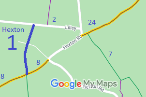
Map showing Hexton 1 bridleway
Annotated map reproduced courtesy of Googlemaps.
This route starts at a junction with Lilley 16 bridleway and the Icknield Way (Hexton 8 and Lilley 23 byway) and runs generally northwards to a public road, not far from Hexton 2 bridleway.

There are periodic complaints about the large number of gates in the vicinity of the farm. If you can't open a gate from horseback, please report it on the county council's form as a public right of way structure problem.

We need a volunteer to photograph this route for this year's Access and Riding Rights of Way Survey. It's easy - just take photographs (safely) when you use the path. Find out more!
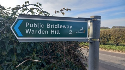
Hexton 1 sign at northern end

Sign at road junction
Photo: Phil Wadey, 9 Mar 25
Legal History
1837: Hexton 1 was shown on the Hexton tithe map as part of parcel 201, a bridleway owned by the surveyor of highways and not subject to an apportionment.
1938: The route is shown as Hexton BW 6 on the Hertfordshire County Council ROW survey. Map Hitchin West 6 (Herts 9 NW).
1 Nov 1953: Hexton 1 was recorded as a bridleway on the original definitive map and statement. DM sheet DM4-27 (Herts 11 NW).
31 Dec 1977: Hexton 1 was recorded as a bridleway on the special review draft map and statement. DM sheet SR-19.
13 Jul 2022: Council footpath sign spotted at northern end of path. Reported to HCC as should say bridleway. Reference: 401002813300.
27 Aug 2022: Council footpath sign still in place at northern end of path. Reported to HCC as should say bridleway. Reference: 401003632833.
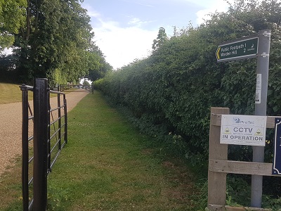
7 Dec 2024: Council footpath sign still in place at northern end of path. Reported to HCC as should say bridleway. Reference: 401004473632.
9 Mar 2025: Council bridleway sign spotted at northern end of path.
Definitive Statement (4 Dec 2015)
Path: [Hexton] 1.  Status: Bridleway.  Definitive Map sheet: 19
Commences from Icknield Way at parish boundary and junction with BR16 (Lilley) SW of Floodhole Plantation thence N to county road N of Mortgrove.

The statement is unchanged since the 1953 version.

Maintainability
This route is maintainable at the public expense because it was a footpath or bridleway existing before 30 Apr 1959.
Hexton 1 sign at northern end

Sign at road junction
Photo: Phil Wadey, 4 Aug 2020

It took over four years from our reporting of the erroneous footpath sign on Hexton1 until the Hertfordshire County Council replaced it!

© 2025 Patchetts Green Bridleways Trust.

Stats2