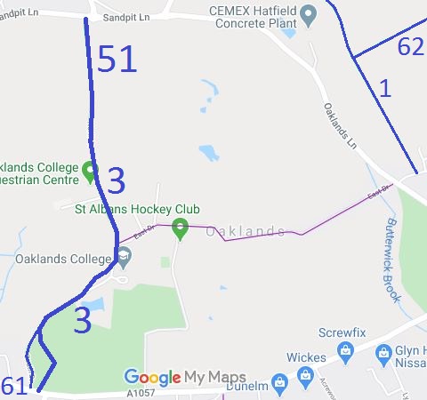
Annotated map reproduced courtesy of Googlemaps.
We need a volunteer to photograph this route for this year's Access and Riding Rights of Way Survey. It's easy - just take photographs (safely) when you use the path. Find out more!
| Paths Greenways Bridleways Tracks | ||
| PG: OBJECTS: PROMOTION: Sandridge 51 BW, Colney Heath 3 BW and 61 BW | ||
Annotated map reproduced courtesy of Googlemaps. |
This bridleway starts as Sandridge 51 on Sandpit Lane. It runs generally south along 'North Drive', becoming Colney Heath 3 at the parish boundary, to Oaklands College then south-west along 'South Drive' to a junction with bridleway Colney Heath 61. Both Colney Heath 61 and Colney Heath 3 then run to the A1057 St Albans to Hatfield Road, near the junction with Hill End Lane.
We need a volunteer to photograph this route for this year's Access and Riding Rights of Way Survey. It's easy - just take photographs (safely) when you use the path. Find out more! |
| Legal History 20 Jun 1953: Colney Heath 3 was recorded as bridleway on the original definitive map and statement. Sheet DM3-23. The parish boundary moved and part of Colney Heath 3 was renumbered as Sandridge 51. 31 May 2013: The County Council and the landowner entered into a Public Path Creation Agreement to establish a minimum width for Colney Heath 3 BW and to dedicate bridleway rights on Colney Heath 61. 3 Jan 2014: The Hertfordshire County Council (Colney Heath 3 and 61) Legal Event Modification Order 2014 altered the definitive map to show Colney Heath 61, and modified the definitive statement to record the details for both paths. 21 Aug 2023: Hertfordshire County Council advise that a Temporary Traffic Regulation Order has been made prohibiting use for 8 weeks while drainage works taken place. |
Definitive Statement (4 Dec 2015)
Path: [Colney Heath] 3. Status: BW. Definitive Map sheet: 68 Commences from parish boundary at junction with BR51 (Sandridge) at TL 1813 0801 thence generally S along Oaklands Drive for approximately 690 metres to a point approximately 200 metres north of The Lodge at TL 1796 0745 then S to St Albans - Hatfield Road at Lodge. Width: Varies from 6 to 12 metres and subject to mature trees between TL 18130801 and TL 1796 0745 as shown on the Oaklands College Public Path Creation Agreement 2013. Limitations: None
Path: [Colney Heath] 61. Status: BW.
Definitive Map sheet: 68
Path: [Sandridge] 51. Status: BW.
Definitive Map sheet: 68 |
|
Location Information
Postcode for SATNAV for anyone inspecting path (northern end): AL4 9JF. Southern end (St Yon Court): AL4 0TR. |
© 2024 Patchetts Green Bridleways Trust.
File reference: ED132.
