Legal History
20 Jun 1953: The route was recorded as a bridleway on the original (1953) definitive map and statement for Hertfordshire. DM sheets DM3-35 and DM3-41.
The route was also recorded as a bridleway (Chalfont St Peter 44 and Chenies 52) in Buckinghamshire.
31 Dec 1977: Rickmansworth 2 was shown as a bridleway on the special review draft map and statement. DM sheet SR-88 (TQ09SW).
14 Mar 2016: Application made for restricted byway status. HCC reference 3R/91.
14 Mar 2016: Application made for restricted byway status. BCC reference 16855 BAS. This was turned down on the grounds that the route is actually outside Buckinghamshire!
4 Jul 2016: The Hertfordshire County Council (Rickmansworth 2, 70 and 71) Modification Order 2016 (confirmed 21 Oct 2016) split the original Rickmansworth 2 BW into sections, removed those that had been found to be in Buckinghamshire, and renumbered and upgraded the remaining section as Rickmansworth 71 RB. The application for the last piece of Rickmansworth 2 and Chorleywood 33 to be upgraded was not determined and remains in the queue.
|
Definitive Statement (4 Dec 2015)
Path: [Chorleywood] 33. Status: Bridleway.
Definitive Map sheets: 82, 88
Shire Lane. Commences from junction with BR24 and BR2 (Rickmansworth UD), NE of
Newlands thence W along County boundary to SE corner of Philipshill Wood thence NE
along boundary to junction with Heronsgate Road, NW of the Swillett.
Path: [Rickmansworth] 2. Status: Bridleway.
Definitive Map sheet: 88
Commences from the county boundary at Chalfont Road and a junction with Chalfont St Peter 44 at TQ 0152 9343 and thence northward along Shire Lane to enter Chorleywood urban District NE of Newlands.
|
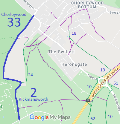
 As part of the British Horse Society's work to record paths before
Path Extinguishment Day,
it was identified that this route appears to be an old road, and so an application has been made to record it as a restricted byway. An application was also made to Buckinghamshire County Council, as the route was also recorded on their definitive map, as Chalfont St Peter 44 and Chenies 52 bridleways. However, Buckinghamshire's investigation showed that the route fell entirely in Hertfordshire so it will be removed from the Buckinghamshire map in due course.
