Legal History
2 Feb 1953: Buntingford 9 was recorded as a CRB (Carriage Road used as a Bridleway) on the original definitive map.
2 May 2006: Restricted Byway rights were confirmed or created on this path by virtue of ss 47 and 48 Countryside and Rights of Way Act 2000.
9 Mar 2013: Application made to record the gap between Buntingford 9 and Hare Sreet Road. HCC reference EH/402.
24 Mar 2016: The Hertfordshire County Council (Hormead 33) Modification Order 2016 (confirmed 3 Jun 2016) added Hormead 33 to the definitive map and updated the statement for Buntingford 9.
|
| Application Process |
| Path |
Application |
Certificate |
Direction |
Inv Report |
Order |
Confirmed |
| EC681 |
9 Mar 2013 EH/402 |
2 Sep 2013 |
Not needed |
30 Oct 2015 |
24 Mar 2016 |
3 Jun 2016 |
|
Definitive Statement (14 Mar 2016)
Path: [Buntingford] 9. Status: Restricted Byway.
Definitive Map sheets: 15 and 24
Commences at a junction with Hormead 33 at TL 3814 2992 on the parish boundary thence W and N along Green Lane crosses Restricted Byway 8. Continues N to boundary with Wyddial parish SE of Beauchamps Plantation.
Path: [Hormead] 33. Status: Restricted Byway.
Definitive Map sheet: 24
Commences at a junction with Hare Street Road (public road) at TL 3813 2982 running NNE along a track for approx 102m to a junction with Buntingford RB 9 and the parish boundary at TL 3814 2992.
Width: Varies between 7m and 13m between TL 3813 2982 and TL 3814 2992 as shown in the Hertfordshire County Council (Hormead 33) Modification Order 2016.
Limitations: None
|
Maintainability
Hormead 33 is maintainable at the public expense because it was a highway before 1835.
Buntingford 9 is maintainable at the public expense by virtue of s.49(1) Countryside and Rights of Way Act 2000. [RB converted from RUPP]
|
|
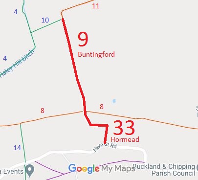
 As part of the British Horse Society's work to record paths before Path Extinguishment Day, it was spotted that Buntingford 9 did not reach the road. The last 102m fell in Hormead parish and had not been recorded. The historical evidence showed a continuous route, so an application was made in 2013 to record the gap. The County Council agreed with the application and an order was made in 2016 and confirmed unopposed.
This is a good example of 'perfectly obvious paths' that would be extinguished by the Countryside and Rights of Way Act 2000 if an application had not been made in time.
