Paths Greenways Bridleways Tracks
 PG: OBJECTS: PROMOTION: Aston: Stevenage Horse and Pony Route section from Skeggs Lane to Tatlers Lane
Stevenage Horse and Pony Route: Last: Turn left on to Tatlers Lane then right onto Skeggs Lane (Aston 35) Next: Path East of Edmunds Drive (Stevenage Borough Council section)  SHPR 
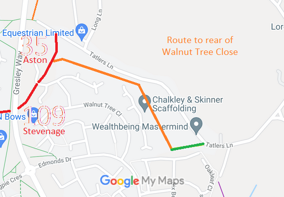
Map showing unrecorded route at the rear of Walnut Tree Close
Annotated map reproduced courtesy of Googlemaps.
The orange route runs from Aston 35 restricted byway generally eastwards then south-eastwards to a junction with Beehive Way. The green route runs from the orange route eastwards to a junction with Tatlers Lane.

The final section is part of an old road, and an application has been made on historical evidence to have it recorded. The rest of the orange route has been scheduled by Stevenage Borough Council (previously Stevenage Development Corporation) as part of the Stevenage Horse and Pony Route. When permission was given for the adjoining houses, a strip was reserved for the non-motorised user route.

We need a volunteer to photograph this route for this year's Access and Riding Rights of Way Survey. It's easy - just take photographs (safely) when you use the path. Find out more!


Legal History
1840: The green route was shown on the Aston tithe map as not subject to an apportionment.
8 Dec 2004: The orange and green routes are described as part of the existing Stevenage Horse and Pony Route on the Stevenage Local Plan map.
8 Sep 2018: Application to record green route as a restricted byway. HCC reference EH/469.

© 2025 Patchetts Green Bridleways Trust. File references: EC345A, EC874.

Stats2