Paths Greenways Bridleways Tracks
 PG: OBJECTS: PROMOTION: Wheathampstead 95
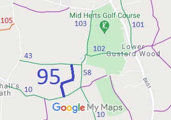
Map showing Wheathampstead 95 bridleway
Annotated map reproduced courtesy of Googlemaps.
This path starts from Wheathampstead 43 bridleway and continues generally southwards to Wheathampstead 10 bridleway.

We need a volunteer to photograph this route for this year's Access and Riding Rights of Way Survey. It's easy - just take photographs (safely) when you use the path. Find out more!

Legal History
Definitive Statement (4 Dec 2015)
Path: [Wheathampstead] 95.  Status: Bridleway.  Definitive Map sheet: 42
Commences from BR43 S of Heron's Farm thence generally S to join BR10.
Maintainability
This route is maintainable at the public expense because it was a highway before 1835.
This route is maintainable at the public expense because it was a footpath or bridleway existing before 30 Apr 1959.
This route is maintainable at the public expense by virtue of s.49(1) Countryside and Rights of Way Act 2000. [RB converted from RUPP]
This route is maintainable at the public expense by virtue of para 7 of Sch 3 to the Countryside Act 1968. [Converted from RUPP]
This route is maintainable at the public expense by virtue of s.54(4) Wildlife and Countryside Act 1981. [Converted from RUPP]
This route is maintainable at the public expense by virtue of s.36(2)(d) Highways Act 1980 as it was created by a Public Path Creation Agreement. [Dedicated by PPCA]

© 2024 Patchetts Green Bridleways Trust.

Stats2