Paths Greenways Bridleways Tracks
 PG: OBJECTS: PROMOTION: Wheathampstead 54
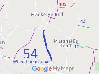
Map showing Wheathampstead 54
Annotated map reproduced courtesy of Googlemaps.
This route runs from Mackerye End Lane (public road) and continues generally southeastwards to Castle Rise (public road).

We need a volunteer to photograph this route for this year's Access and Riding Rights of Way Survey. It's easy - just take photographs (safely) when you use the path. Find out more!

BHS The sudden installation of a gate across the route in 1996 led to the British Horse Society's County Access Officer collecting user evidence to have the path recorded. This had happened after a change in ownership of the land. The society was able to collect enough evidence to enable the council to make an order recording the route. The subsequent order went though unopposed.

Legal History
1938: The route is not shown on the Hertfordshire County Council ROW survey. Map St Albans Rural 4.
20 Jun 1953: The route was recorded as a footpath on the original definitive map and statement. DM sheet DM3-07.
31 Dec 1977: The route was shown as a footpath on the special review draft map and statement. DM sheets SR-42 and SR-56.
28 Feb 1996: Application for bridleway based on user evidence. HCC reference STA/92.
22 Nov 2012: The Hertfordshire County Council (Wheathampstead 54) Modification Order 2012 (confirmed 8 Mar 2013) recorded the bridleway rights on this path.
Definitive Statement (4 Dec 2015)
Path: [Wheathampstead] 54.  Status: Bridleway.  Definitive Map sheet: 42 and 56
Commences from Mackerye End Lane (public highway), SE of Mackerye End House at TL 1569 1550 then continues generally SSW for approx. 40m then SSE for approx. 560m to join Castle Rise (public highway) at TL 1585 1493.
Width: 4m
Limitations: None
Maintainability
This route is maintainable at the public expense because it was a footpath or bridleway existing before 30 Apr 1959.

© 2024 Patchetts Green Bridleways Trust. File reference: EC425.

Stats2