Paths Greenways Bridleways Tracks
 PG: OBJECTS: PROMOTION: Stanstead Abbots Marsh Lane
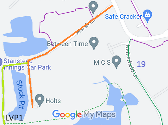
Map showing recorded Stanstead Abbots paths
Annotated map reproduced courtesy of Googlemaps.
This route starts by Holts and continues northwards to a junction with the Stanstead Abbots LVP1 riding route. It continues generally northeastwards to the B181 Roydon Road, not far from Stanstead Abbots 19 bridleway

At the time of the BHS 2021 Access Survey (5 Sep 21), there were no obstructions on the route.

BHS PGBT As part of the Patchetts Green Bridleways Trust's and the British Horse Society's work to record paths before Path Extinguishment Day, it was spotted that Marsh Lane did not appear eitehr on the definitive map or on the County Council's List of Streets. Accordingly its status is potentially at risk of being removed by s.53 Countryside and Rights of Way Act 2000. The historical evidence showed that the route has existed for over a hundred years, so an application was made in 2023 to record it.

Legal History
1910: Marsh Lane was shown as a white road at the time of the Inland Revenue valuation.
2 Feb 1953: Marsh Lane was not recorded on the original definitive map and statement. DM sheet DM2-26 (Herts 30 SW).
31 Dec 1977: Marsh Lane was not shown on the special review draft map and statement. DM sheet SR-60.
Definitive Map sheet: 60
[This path is not yet recorded and so there is no definitive statement.]

© 2023 Patchetts Green Bridleways Trust. File reference: EC1203.