Paths Greenways Bridleways Tracks
 PG: OBJECTS: PROMOTION: Sacombe 20 RB and Bengeo Rural 18 BW
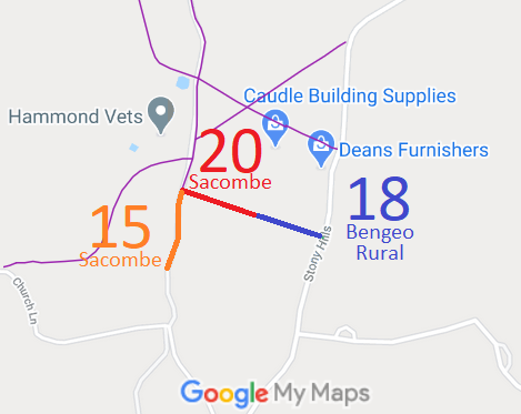
Map showing Sacombe 20 and Bengo Rural 18
Annotated map reproduced courtesy of Googlemaps.

We need a volunteer to photograph this route for this year's Access and Riding Rights of Way Survey. It's easy - just take photographs (safely) when you use the path. Find out more!

BHS As part of the British Horse Society's work to record paths before Path Extinguishment Day, it was spotted that Sacombe 20, a restricted byway, was joined by a footpath on one side and a bridleway on the other. Historical research revealled that both sides appeared to be restricted byways, so applications were made to upgrade Bengeo Rural 18 and Sacombe 15.

Legal History
2 Feb 1953: Sacombe 20 was recorded as a CRB (Carriage Road used as a Bridleway) on the original definitive statement. Bengeo Rural 18 was recorded as a bridleway. DM sheet DM2-21 (Herts 29 NE).
31 Dec 1977: Sacombe 20 and Bengeo Rural 18 were shown as a footpaths on the special review draft map and statement. There must have been objections. DM sheet SR-45.
2 May 2006: Restricted Byway rights were confirmed or created on Sacombe 20 by virtue of ss 47 and 48 Countryside and Rights of Way Act 2000.
31 Mar 2013: Application to upgrade part of Sacombe 15 FP to RB. HCC reference EH/417.
8 Apr 2013: Application to upgrade Bengeo Rural 18 BW to RB. HCC reference EH/416.
Definitive Statement (4 Dec 2015)
Path: [Sacombe] 20.  Status: Restricted Byway.  Definitive Map sheet: 45
Commences from FP15 S of South End thence SE to parish boundary to join BR18 (Bengeo).

Path: [Bengeo Rural] 18.  Status: Bridleway.  Definitive Map sheet: 45
Commences at junction with county road N of Stoneyhills thence NW to parish boundary at junction with Restricted Byway 20 (Sacombe parish).

© 2021 Patchetts Green Bridleways Trust. File reference: EC747.