| Paths Greenways Bridleways Tracks | ||
| PG: OBJECTS: PROMOTION: Redbourn Hill Farm Lane | ||
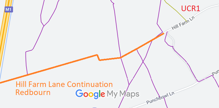
![]() Annotated map reproduced courtesy of Googlemaps. |
This route starts from Hill Farm Lane (recorded public road) at its junction with Redbourn 37 footpath, and continues generally westwards to the boundary of the M1 motorway.
We need a volunteer to photograph this route for the Access and Riding Rights of Way Survey. It's easy - just take photographs (safely) when you use the path. Find out more! |

|||
As part of the British Horse Society's work to record paths before
Path Extinguishment Day,
it was spotted that the County Council's record of this old road had vanished, even though a hundred years ago it was a perfectly good lane. The historical evidence showed a continuous route, broken by the M1 motorway, so an application was made in 2020 to record the route. This is important because it is expected that the area adjacent to the M1 will become a housing estate, and amenity routes will have a chance of being reconnected.
| ||||
| Legal History 9 Feb 2006: The City and District of St Albans Council (Redbourn 37) Diversion Order 2006 (confirmed 4 Sep 2007) diverted part of Redbourn 37 FP along Hill Farm Lane despite BHS objections that the land already carried highway rights. 14 Feb 2007: Letter on behalf of Crown Estate Commissioners offering to dedicate the section of Redbourn 37 FP on Hill Farm Lane as restricted byway to remove objection to FP diversion order. 29 Jun 2012: The Hertfordshire County Council (Redbourn 37) Legal Event Modification Order 2012 altered the route to reflect the diversion order effect on the definitive map and statement 5 Feb 2020: Application for restricted byway. HCC reference STA/67.
|
© 2023 Patchetts Green Bridleways Trust. File reference: EC278. HCC reference: STA/67.