Legal History
1938: The route is shown as Langley 6 BW (blue dots) on the Hertfordshire County Council
ROW survey.
Maps Hitchin Rural West 15 (Herts 20 NW) and 16 (Herts 20 NE).
1 Nov 1953: The route was recorded as a bridleway on the original definitive map and statement. DM sheet DM4-34, DM4-40, DM4-41.
31 Dec 1977: The route was shown as a footpath on the special review draft map and statement. Objections were made. DM sheet SR-29.
Aug 1995: The county council determined the Special Review case, and decided the route was a bridleway rather than a footpath.
Aug 2025: Planning permission affects the western end of this route.
25 Mar 2026: Consultation on the draft North Hertfordshire District Council (Langley 5 Bridleway) Diversion Order 2026 (under s.257 Town and Country Planning Act 1990) circulated to the usual consultees. Comments due by 10 Apr 26.
|
|
Definitive Statement (4 Dec 2015)
Path: [Langley] 5. Status: Bridleway.
Definitive Map sheet: 29
Commences from parish boundary approx. 15 yards S of High Broomin Wood and junction with FP37 (Stevenage) thence SW across Dyes Lane to join B656 at Langley Bolton.
|
Maintainability
This route is maintainable at the public expense because it was a footpath or bridleway existing before 30 Apr 1959.
|
|
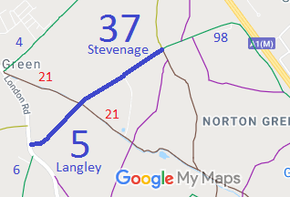

 Following the grant of planning permission at the southwestern end of Langley 5 bridleway, it is likely that there will be an order to divert the bridleway. The British Horse Society and the Patchetts Green Bridleways Trust will be seeking a diverions that achieves the safest crossing of London Road that we can get, to link Langley 5 bridleway to Langley 6 bridleway.
