Paths Greenways Bridleways Tracks
 PG: OBJECTS: PROMOTION: Great Ashby 19 and Stevenage 102 BW
Stevenage Horse and Pony Route: Anti-clockwise: Botany Bay Lane. Clockwise: Great Ashby 13A.  SHPR 
Map showing Great Ashby paths
Annotated map reproduced courtesy of Googlemaps.
This route starts from Botany Bay Lane (public road) (shown in orange) and continues generally southeastwards to Great Ashby Way (public road) and Great Ashby 12 bridleway.

We need a volunteer to photograph this route for this year's Access and Riding Rights of Way Survey. It's easy - just take photographs (safely) when you use the path. Find out more!
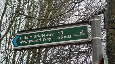
Sign at junction with Great Ashby Way

Sign at Great Ashby Way
Photo: Phil Wadey, 10 Dec 2023
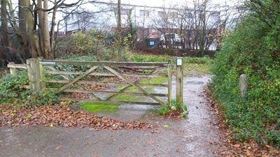
View from junction with Great Ashby Way

View from Great Ashby Way
Photo: Phil Wadey, 10 Dec 2023

Legal History
1983: The route is shown in Stevenage Borough Council leaflet as an on-road part of the SHPR which is stated as being open for use.
23 Mar 1998: The Stopping up of Highways (County of Hertfordshire) (No.1) Order 1998 changed this old road into a public bridleway.
28 Jul 2000: The Hertfordshire County Council (Stevenage 102 and Graveley 19) Legal Event Modification Order 2000 added the bridleway to the definitive map and statement.
Definitive Statement (4 Dec 2015)
Path: [Great Ashby] 19.  Status: Bridleway.  Definitive Map sheet: 22
Commences from the end of the vehicular length of Botany Bay Lane (5U239) (at TL 25495 27375) thence eastwards and southwards to the northern edge of Great Ashby Way (at TL 25565 27315). Recommences at the southern edge of Great Ashby Way (at TL 25580 27295) thence generally south eastwards to junctions with FP11 Graveley (at TL 25800 27125) and FP91 Stevenage (at TL 25840 27105), thence continuing eastwards to a junction with BR12 and FP13a Great Ashby (formerly Graveley) (at TL 26060 27080) and another junction with Great Ashby Way at TL 26075 27080). This route is also known as Stevenage 102.
Width: Between 5m and 18m as shown hatched on the plan forming part of the Hertfordshire County Council (Stevenage 102 and Graveley 19) Legal Event Modification Order 2000
Limitations: None.

Path: [Stevenage] 102.  Status: Bridleway.  Definitive Map sheet: 22
Commences from the end of the vehicular length of Botany Bay Lane (5U239) (at TL 25495 27375) thence eastwards and southwards to the northern edge of Great Ashby Way (at TL 25565 27315). Recommences at the southern edge of Great Ashby Way (at TL 25580 27295) thence generally south eastwards to junctions with FP11 Great Ashby (formerly Graveley) (at TL 25800 27125) and FP91 Stevenage (at TL 25840 27105), thence continuing eastwards to a junction with BR12 and FP13a Great Ashby (formerly Graveley) (at TL 26060 27080) and another junction with Great Ashby Way at TL 26075 27080). This route is also known as Great Ashby (formerly Graveley) 19.
Width: Between 5m and 18m as shown hatched on the plan forming part of the Hertfordshire County Council (Stevenage 102 and Graveley 19) Legal Event Modification Order 2000
Limitations: None

Maintainability
This route is maintainable at the public expense because it was a highway before 1835.

© 2024 Patchetts Green Bridleways Trust.

Stats2