Paths Greenways Bridleways Tracks
 PG: OBJECTS: PROMOTION: Flamstead 59 and Great Gaddesden 73 BOAT - Dean Lane
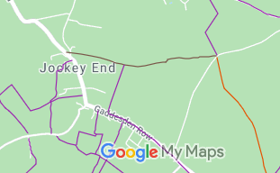
Map showing recorded Flamstead and Great Gaddesden paths
Annotated map reproduced courtesy of Googlemaps.
This route runs from Clements End Road (public highway) opposite Old Ballingdon, eastwards across the parish boundary to Beechwood Lane (public highway) opposite Flamstead 57 restricted byway.

We need a volunteer to photograph this route for this year's Access and Riding Rights of Way Survey. It's easy - just take photographs (safely) when you use the path. Find out more!

BHS As part of the British Horse Society's work to record paths before Path Extinguishment Day, it was spotted that Great Gaddesden 73 did not reach the road at its eastern end. The last 335m fell in Flamstead parish and had not been recorded. The historical evidence showed a continuous route, so an application was made in 2013 to record the gap. The County Council agreed with the application and an order was made in 2019. The objections were eventually withdrawn and so the order was confirmed unopposed. This is a good example of 'perfectly obvious paths' that the Countryside and Rights of Way Act 2000 would prevent the recording of, had an application had not been made in time.

Legal History
20 Jun 1953: Great Gaddesden 73 was recorded as CRB (Carriage Road used as a Bridleway) on the original definitive statement. Flamstead 59 was not recorded. DM sheet DM3-12.
31 Dec 1977: Great Gaddesden 73 was recorded as a byway open to all traffic on the special review draft map and statement. Flamstead 59 was not recorded. DM sheet SR-53.
20 Feb 2013: Application made to record the Flamsead section as a byway. HCC reference DAC/87.
22 Mar 2019: The Hertfordshire County Council (Flamstead 59) Modification Order 2019 (confirmed 24 Oct 2019) added Flamstead 59 to the definitive map and statement as a byway open to all traffic.
Definitive Statement (26 Feb 2019)
Path: [Flamstead] 59.  Status: BOAT.  Definitive Map sheet: 53
Commences from Great Gaddesden BOAT 73 at TL 0450 1401 then runs E along Dean Lane unclassified county road for approx 335m to a junction with Flamstead FP 47 and Beechwood Lane (public highway) opposite Flamstead RB 57 at TL 0483 1406.
Width: Varies between 11m and 17m as shown in the Hertfordshire County Council (Flamstead 59) Modification Order 2019.
Limitations: None

Path: [Great Gaddesden] 73.  Status: BOAT.  Definitive Map sheet: 53
Commences at junction with Clements End Road (public highway) opposite Old Ballingdon Farm thence E along Ballingdon Bottom (Dean Lane) to join Flamstead BOAT 59 (Dean Lane) at TL 0450 1401.

© 2021 Patchetts Green Bridleways Trust. File reference: EC019, EC633

Stats2