| Patchetts Green Bridleways Trust | ||
| PG: OBJECTS: PROMOTION: ST ALBANS: Colney Heath 60 Woodrake Lane | ||
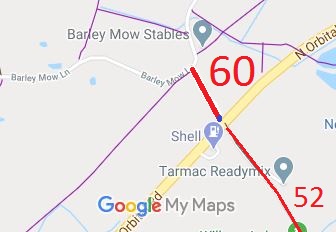
![]() Annotated map reproduced courtesy of Googlemaps. |
Woodrake Lane
runs from Barley Mow Lane and permissive bridleway Colney Heath 27, to the A414, opposite Colney Heath 52 byway that heads into the Tyttenhanger estate. There is no suitable crossing at this point so crossing cannot be recommended for equestrians.
However, the verge between Woodrake Lane and the A414 carriageway is wide and there is enough room to pass walkers or cyclists. We need a volunteer to photograph this route for this year's Access and Riding Rights of Way Survey. It's easy - just take photographs (safely) when you use the path. Find out more! |
![]()
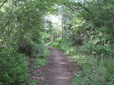
Looking North on Woodrake Lane |
The original aplication was made to record a byway along this old road. The County Council, when it was investigating the rights here, found that a short distance (18 yards) closest to the A414 had been stopped up reserving footpath rights. However, the route was being used by riders. We were fortunate that the then BHS county chairman lived nearby: she was able to collect statements of use of the route from local riders, and so the section that might have been recorded as footpath was actually recorded as bridleway.
|
||
© 2024 Patchetts Green Bridleways Trust.
File reference: EC367.
Legal History
1938: The route is shown as an unclassified road (brown solid line) on the Hertfordshire County Council
ROW survey. Map St Albans Rural 11.
20 Jun 1953: The route was not recorded on the original definitive map and statement.
10 Jan 1969: The London North Orbital Trunk Road (Barley Mow Lane, Colney Heath Side Roads) Order1969 stopped up 18 yards of the route, reserving footpath rights.
2 May 2006: NERC exemption s.67(2)(b) as route not on DM but was on LOS.
25 Jan 2010: Application made to record Woodrake Lane. HCC reference STA/130.
19 May 2017: The Hertfordshire County Council (Colney Heath 60) Modification Order 2017 was made to record this route mostly as a byway and with a short distance as a bridleway.
11 Aug 2017: Order confirmed by Hertfordshire County Council as an unopposed order.
Application Process
Path
Application
Certificate
Direction
Inv Report
Order
Confirmed
EC367
25 Jan 2010 STA/130
28 May 2010
Not needed
21 Oct 2016
19 May 2017
11 Aug 2017
Definitive Statement (10 Mar 2017)
Path: [Colney Heath] 60. Status: BOAT/Bridleway
Woodrake Lane. Commences as BOAT from junction with Barley Mow Lane (public highway) and Colney
Heath FP27 at TL 1890 0579 running along Woodrake Lane
generally SSE for approx 155m to TL 1898 0584. Continuing as BR generally SSE
for approx 16m to join the A414 North Orbital Road (public highway) at TL 1898 0582.
Width: Varies between 5.1m and 17m as shown in the Hertfordshire County
Council (Colney Heath 60) Modification Order 2017.
Limitations: Bollards at TL 1898 0582.
Maintainability
This route is maintainable at the public expense because it was a highway before 1835.
This route is maintainable at the public expense because it was a footpath or bridleway existing before 30 Apr 1959.
