Paths Greenways Bridleways Tracks
 PG: OBJECTS: PROMOTION: Cheshunt Parish Boundary route (including parts of Cheshunt 30, 29, 27)
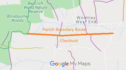
Map showing lane along parish boundary, Cheshunt
Annotated map reproduced courtesy of Googlemaps.

This route starts on Holy Cross Hill (public road) and runs generally westwards along the parish boundary to Brickendon Liberty 65 BW. Parts of the route are recorded as Cheshunt 30, 29 and 27 FP.
BHSAs part of the British Horse Society's work to record paths before Path Extinguishment Day, it was spotted that this route was unrecorded. An application has been made to record it as a restricted byway based on historical evidence.

Legal History
2 Feb 1953: The route was not recorded on the original definitive map and statement save for a short portion of Cheshunt 30, 29 and 27 FP. DM sheet DM2-32.
26 Jul 2017: Application for restricted byway. HCC reference BRX/64.

© 2022 Patchetts Green Bridleways Trust. File reference: EC1006.

Stats2