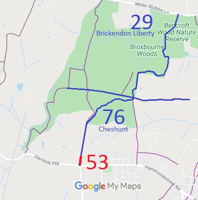
Annotated map reproduced courtesy of Googlemaps.
The section in red is Cheshunt 53 which needs recording properly on the definitive map.
| Paths Greenways Bridleways Tracks | ||
| PG: OBJECTS: PROMOTION: Cheshunt 53 and 76, and Brickendon Liberty 29 | ||
| We're collecting user evidence for the council now: Download user evidence form - Read the Instructions | ||
Annotated map reproduced courtesy of Googlemaps. |
This route starts at White Stubbs Lane and runs generally southwards to a junction with Beaumont Lane then continuing generally south west and southward to Darnacle Hill.
The section in red is Cheshunt 53 which needs recording properly on the definitive map. |
|||
| If you have ridden the red route, please download a user evidence form and then follow the instructions and return the form to us. It only takes a few minutes to fill in (the whole form fits on one side of a piece of A4 paper). If you have any other questions, please email us. | ||||
| Legal History 31 Dec 1977: Cheshunt 53 was shown as a footpath on the special review draft map and statement. DM sheets SR-71 (TL30NW) and SR-80 (TL30SW). 19 Aug 2000: Two dedication agreements came into force, creating bridleways 53 Cheshunt and 29 Brickendon Liberty. 19 Jun 2009: The Hertfordshire County Council (Cheshunt 76 and Brickendon Liberty 29) Legal Event Modification Order 2009 recorded the bridleways. |
Definitive Statement (4 Dec 2015)
Path: [Brickendon Liberty] 29. Status: BW. Definitive Map sheet: 71 Public Bridleway running from the parish boundary at TL 3227 0576 east for approximately 300 metres, north for approximately 200 metres and west for approximately 50 metres. Continuing north (fording Wormleybury brook) for approximately 280 metres to the junction of Bencroft Wood and Wormley Wood at TL 3259 0624. Then continuing north east for approximately 300 metres to a junction with White Stubbs Lane at TL 3273 0649. Width: 4 metres subject to mature trees. 1.52 metres at TL 3259 0624 and TL 3273 0649. Limitations: The Woodland Trust reserves the right to erect a bridlegate or other similar structure at TL 3259 0624. Hertfordshire County Council reserves the right to erect a bridlegate or other similar structure at TL 3259 0624 and TL 3273 0649 Path: [Cheshunt] 76. Status: BW.
Definitive Map sheets: 71 and 80 |
© 2023 Patchetts Green Bridleways Trust.
File reference: EC057.
