Paths Greenways Bridleways Tracks
 PG: OBJECTS: PROMOTION: Buntingford 6
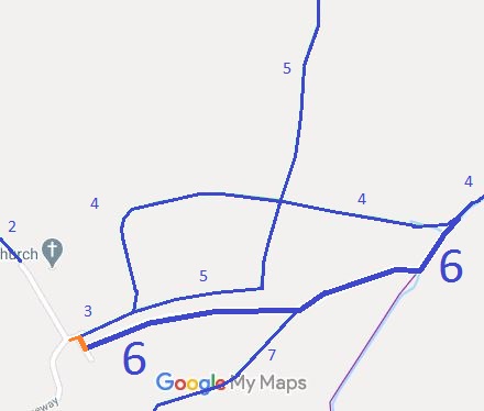
Map showing Buntingford 6
Annotated map reproduced courtesy of Googlemaps.
Buntingford 6 bridleway runs from a spur to the public road next to St Bartholomew's Church to a junction with Buntingford 7 bridleway then to end on Buntingford 4 bridleway.

We need a volunteer to photograph this route for the Access and Riding Rights of Way Survey. It's easy - just take photographs (safely) when you use the path. Find out more!

BHSThanks to a good spot by a Ramblers volunteer, it was noted that Buntingford 6's legal record did not explicitly state that it met the recorded public road to the west. As part of the British Horse Society's work to record paths before Path Extinguishment Day an application to record the gap is in preparation.

Legal History
2 Feb 1953: Buntingford 6 was recorded as a bridleway on the original definitive map and statement. DM sheet DM1-10 (Herts 14 NW).
Definitive Statement (4 Dec 2015)
Path: [Buntingford] 6.  Status: Bridleway.  Definitive Map sheet: 15
Commences S of Layston Church (just S of first part of BR5) then NE to join BR4.
Maintainability
This route is maintainable at the public expense because it was a footpath or bridleway existing before 30 Apr 1959.

© 2024 Patchetts Green Bridleways Trust. File reference: EC1136.

Stats2