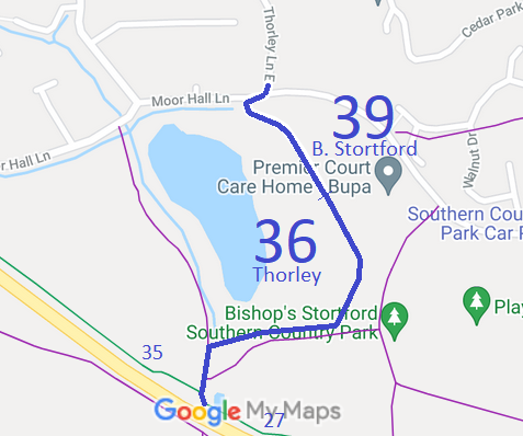
Annotated map reproduced courtesy of Googlemaps.
We need a volunteer to photograph this route for the Access and Riding Rights of Way Survey. It's easy - just take photographs (safely) when you use the path. Find out more!
| Paths Greenways Bridleways Tracks | ||
| PG: OBJECTS: PROMOTION: Bishop's Stortford 39 BW and Thorley 36 BW | ||
Annotated map reproduced courtesy of Googlemaps. |
The route runs from Thorley Lane generally southeastwards as Bishop's Stortford 39. Then, as Thorley 36 BW it continues south east, then south-west, west and south to join Thorley 35 bridleway and Thorley 27 bridleway.
We need a volunteer to photograph this route for the Access and Riding Rights of Way Survey. It's easy - just take photographs (safely) when you use the path. Find out more! |
| Legal History The numbering of paths in Bishop's Stortford before 2000 was unlike that in the rest of Hertfordshire! 21 May 1999: The Hertfordshire County Council (Thorley Development) Legal Event Modification Order 1999 added Bishop's Stortford L17 BW (now 39 BW) to the definitive map and statement. 2009: The Bishops Stortford Southern Country Park Creation Agreement 2009 created the Thorley 36 bridleway. |
Definitive Statement (4 Dec 2015)
Path: [Bishop's Stortford] 39. Status: Bridleway. Definitive Map sheet: 48 Commences from a junction with Thorley BR36 at TL 4745 1938 thence generally NW for approx 150m to Moor Hall Lane at TL 47379 19496 thence generally NE for approx 15m to Thorley Lane at TL 47389 19506. Width: 4m between TL 4745 1938 and TL 4736 1948. Varies between approx 1m and 10m as shown hatched in the Hertfordshire County Council (Thorley Development) Legal Event Modification Order 1999 between TL 47379 19496 and TL 47389 19506. Limitations: None between TL 4745 1938 and TL 4736 1948. Path: [Thorley] 36. Status: Bridleway.
Definitive Map sheet: 48 |
© 2023 Patchetts Green Bridleways Trust.
