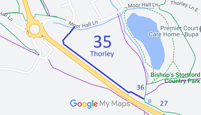
Annotated map reproduced courtesy of Googlemaps.
We need a volunteer to photograph this route for this year's Access and Riding Rights of Way Survey. It's easy - just take photographs (safely) when you use the path. Find out more!
| Paths Greenways Bridleways Tracks | ||
| PG: OBJECTS: PROMOTION: Thorley 35 | ||
Annotated map reproduced courtesy of Googlemaps. |
This bridleway starts from the junction of Thorley 27 bridleway and Thorley 36 bridleway, and continues generally northwestwards before turnng northeastwards to end on Moor Hall Lane (public road).
We need a volunteer to photograph this route for this year's Access and Riding Rights of Way Survey. It's easy - just take photographs (safely) when you use the path. Find out more! |
| Legal History 2009: Created by The Bishops Stortford Southern Country Park Creation Agreement 2009. |
Definitive Statement (4 Dec 2015)
Path: [Thorley] 35. Status: Bridleway. Definitive Map sheet: 48 Commencing from a junction with Moor Hall Lane (county road) at TL 4708 1940 and continues generally SW for approx 70m to TL 4705 1935 and continuing generally SE for approx 350m to a junction with BR36 at TL 4732 1917. Width: 4m as shown on The Bishops Stortford Southern Country Park Creation Agreement 2009 Limitations: None |
© 2023 Patchetts Green Bridleways Trust.
