| Paths Greenways Bridleways Tracks | ||
| PG: OBJECTS: PROMOTION: Aspenden 5 | ||
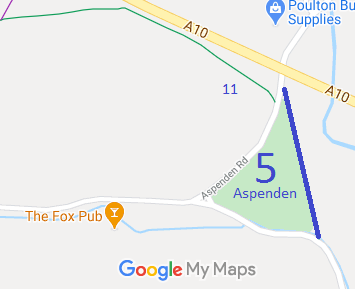
![]() Annotated map reproduced courtesy of Googlemaps. |
This route starts on Aspenden Road, near Aspenden 11 bridleway and runs generally southwards to a junction with the Aspenden to Westmill road.
A volunteer has photographed this route for the 2021/22 Access and Riding Rights of Way Survey, and the page will be updated shortly. Find out more! At the time of the BHS 2022 Access Survey (11 Sep 22), no gates were across the path, but there was a (short) narrow bridge at the southern end. The signposts at each end incorrectly read 'footpath', and the one at the southern end was completely overgrown so unable to be spotted from the road. Both signage faults were reproted to the County Council on 11 Sep 22. |
|||
The East Herts Footpaths Society spotted that the historical evidence showed that Aspenden 5 should be recorded as a bridleway. An application was made in 1997 to record the route.
The County Council agreed with the application and an order was made in 2018 and confirmed unopposed.
This is a good example of legally set out equestrian rights that would be extinguished by the Countryside and Rights of Way Act 2000 if an application had not been made in time. | ||||
| Legal History 1 Oct 1869: Set out as 'public bridleway and footway No 15' on the Inclosure Map of Aspenden. 2 Feb 1953: The route was recorded as a footpath on the original definitive map and statement. DM sheet DM1-10. 31 Dec 1977: The route was shown as a footpath on the special review draft map and statement. DM sheet SR-24. 19 Aug 1997: EHFS Application to upgrade FP 5 to BW. HCC reference EH/134. 27 Apr 2018: The Hertfordshire County Council (Aspenden 02, 05, 11 and Buntingford 44) Modification Order 2018 (confirmed 23 Aug 2018) upgraded Aspenden 5 FP to BW amongst other changes. 11 Sep 2022: Footpath signs (should be bridleway signs) reported to HCC, reference 401002938766 (S end) and 401002938770 (N end). 11 Sep 2022: Overgrowth on southern signage reported to HCC, reference 401002938767. |
Definitive Statement (18 Apr 2018)
Path: [Aspenden] 5. Status: Bridleway. Definitive Map sheet: 24 Commences from the N point of Aspenden Recreation Ground at a junction with the Aspenden Road (public highway) at TL 3627 2840 then running generally SSE along the W side of the E boundary of the Recreation Ground for approx 220m to cross The Bourne and join the Aspenden-Westmill public road at TL 3633 2819. Width: 4 feet (1.2m) Limitations: None |
© 2022 Patchetts Green Bridleways Trust. File reference: EC944.