Legal History
2 Feb 1953: Aspenden 2 was recorded as a footpath on the original definitive map and statement. DM sheet DM1-07.
31 Dec 1977: Aspenden 2 was shown as a footpath on the special review draft map and statement. DM sheet SR-14.
19 Aug 1997: EHFS Application to upgrade FP 2 to BW and extend eastwards. HCC reference EH/134.
30 Jul 2016: BHS Application to upgrade FP 2 to BW and extend eastwards. HCC reference EH/134.
27 Apr 2018: The Hertfordshire County Council (Aspenden 02, 05, 11 and Buntingford 44) Modification Order 2018 (confirmed 23 Aug 2018) upgraded Aspenden 2 FP to BW and added Aspenden 11 BW to extended the route east to meet and go beyond the A10.
27 Apr 2018: The Hertfordshire County Council (Aspenden 11 and Buntingford 44) Diversion Order 2018 (confirmed 23 Aug 2018) diverted the parts of the BW east of the A10 to run along the field boundary on the west side of the A10.
22 Mar 2019: The Hertfordshire County Council (Aspenden 11 and Buntingford 44) Legal Event Modification Order 2019 recorded the effect of the diversion order.
22 Mar 2019: The Hertfordshire County Council (Aspenden Old Lane, Buntingford) Extinguishment Order 27 Apr 2018 (confirmed 1 Dec 2020) extinguished the short continuation of Aspenden 2 that would have fallen the east side of the A10. PINS reference ROW/3235465.
11 Sep 2022: Missing bridleway sign on Aspenden 11 eastern end reported to HCC, reference 401002938774.
11 Sep 2022: Footpath sign (should be bridleway sign) on Aspenden 2 reported to HCC, reference 401002938775.
|
Definitive Statement (18 Apr 2018 for Aspenden 2, and 28 Feb 2019 for Aspenden 11)
Path: [Aspenden] 2. Status: Bridleway.
Definitive Map sheet: 24
Chilly Hills. Commences as a FP at SW side of A10 Buntingford Bypass at TL 3591 2860 thence SW to a junction with BR11 at TL 3585 2850, continuing WSW as a BR for approx 45m along the headland to TL 3580 2849 continuing for approx 180m to TL 3564 2843 then continuing between high banks S for approx 120m to join School Lane public highway at TL3563 2831.
Width: 4m between TL 3585 2850 and TL 3580 2849. Varies between 4m and 14m betweeb TL 3580 2849 and TL 3563 2831 as shown in the Hertfordshire County Council (Aspenden 02, 05, 11 and Buntingford 44) Modification Order 2018.
Limitations: None between TL 3585 2850 and TL 3563 2831.
Path: [Aspenden] 11. Status: Bridleway.
Definitive Map sheet: 24
Commences from Aspenden BR02 at TL 3585 2850 then runs E along headland
on S side of bounary for approx 185m to the A10 Buntingford Bypass at
TL 3603 2852 then continues generally SE on the SW side of the boundary along the
field edge for approx 240m to TL 3624 2840 then slanting away from the boundary
for approx 25m to join the Aspenden Road (public highway) approx 10m from the
field boundary at TL 3626 2839.
Width: 4m.
Limitations: None
|
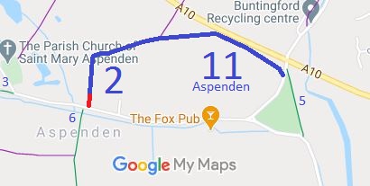

 Following a query from a local rider, the British Horse Society applied for Footpath 2 to be upgraded and extended eastwards. After making the application, it turned out that the East Herts Footpaths Society had already made a similar application, nearly twenty years earlier. The historical evidence showed a continuous route but it was now severed by the A10. The County Council agreed with the application and an order was made in 2018 and confirmed unopposed. In parallel, the County Council diverted the bridleway on the east side of the A10 to enable the bridleway on the west side to be joined to the road.
