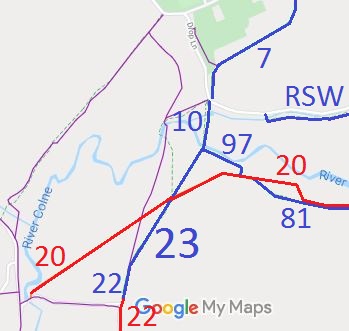
Annotated map reproduced courtesy of Googlemaps.
Part of this route forms part of the Hertfordshire County Council-promoted 6.4 mile Abbot Trail for walkers, riders and cyclists.
| Patchetts Green Bridleways Trust | ||
| PG: OBJECTS: PROMOTION: HERTSMERE: Aldenham 23 BW | ||
| London Orbital Bridleroute: Anti-clockwise: Aldenham 22. Clockwise: St Stephen 10. | H25 | |
Annotated map reproduced courtesy of Googlemaps. |
Aldenham 23 is a bridleway running from bridleway St Stephen 10 at the parish boundary and River Ver, having junctions with bridleway Aldenham 97 and restricted byway Aldenham 20, and ending at the junction with bridleway Aldenham 22.
Part of this route forms part of the Hertfordshire County Council-promoted 6.4 mile Abbot Trail for walkers, riders and cyclists. |
| Legal History 2 Feb 1953: Aldenham 23 was recorded as a bridleway on the original definitive map and statement. |
Definitive Statement (4 Dec 2015)
Path: [Aldenham] 23. Status: Bridleway. Definitive Map sheet: 76 Commences from parish boundary at junction with BR10 (St. Stephen) thence SW across junction of Restricted Byway 20 to join FP22. |
© 2021 Patchetts Green Bridleways Trust.
