Patchetts Green Bridleways Trust
 PG: OBJECTS: PROMOTION: HERTSMERE: Aldenham 22 (including Crab Lane and Commonmeadow Lane)
London Orbital Bridleroute: Anti-clockwise: Aldenham 15. Clockwise: Aldenham 23.  H25 
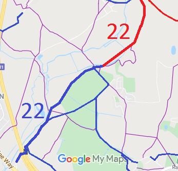
Map showing Aldenham 22 (South)
Aldenham 22 (Southern Section)
Annotated map reproduced courtesy of Googlemaps.
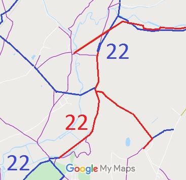
Map showing Aldenham 22 (North)
Aldenham 22 (Northern Section)
Annotated map reproduced courtesy of Googlemaps.
This route starts in Otterspool and runs generally north-eastwards through junctions with bridleways Aldenham 15 (the Berry Grove Woods path), Aldenham 77 and Aldenham 12 before changing into a restricted byway.

The route continues as Crab Lane generally north-eastwards then northwards to junctions with Aldenham 62 (which leads to School Lane, Bricket Wood), and Aldenham 82 (Blackbirds Lane) then as Commonmeadow Lane before becoming a bridleway for a short distance and ending at the junction with bridleway Aldenham 23.

This route forms part of the Hertfordshire County Council-promoted 6.4 mile Abbot Trail for walkers, riders and cyclists.

BHS PGBTThe short (about 100yds) section of bridleway at the northern end was shown as footpath on the definitive map but had been identified as a ridden route in the 1991 ARROW survey. An application to have the map corrected was submitted to the County Council, supported by statements of use, and in due course the map was corrected.

Legal History
1839: The part of Aldenham 22 shown on the Aldenham tithe map is shown as not subject to an apportionment.
20 Jun 1953: This route was recorded as part FP, part bridleway and part CRB (Carriage Road used as a Bridleway) on the original definitive map and statement.
29 Jun 1995: The Hertfordshire County Council (Aldenham 22) Modification Order 1995 changed the definitive map by showing the northernmost bridleway section as a bridleway instead of as a footpath.
2 May 2006: Restricted Byway rights were confirmed or created on the part of Aldenham 22 previously recorded as a RUPP by virtue of ss 47 and 48 Countryside and Rights of Way Act 2000.
Definitive Statement (4 Dec 2015)
Path: [Parish] 22.  Status: FP, BW, RB.  Definitive Map sheets: 76, 84
Commences from parish boundary at River Colne as a FP, thence generally S to a junction with BR 23 at TL 1398 0092, continuing as a BR to a junction with FP 24. Thence continues as a RB S along Commonmeadow Lane and Crab Lane, passing BR62, RB82 at TL 1396 0040 and a junction with FP86 at TQ 1385 9986, thence SW crossing from the S to the N side of the river, passing junction with FP86 at TQ 1355 9962. Continues as a BR generally SW, past junction with FP85 at TQ 1351 9961 and FP/BR 12 at TQ 1343 9959, past FP 65 and FP 90 at TQ 1293 9908, through Otterspool, past junction with BR 15 at TQ 1266 9868 and under county road to parish boundary.

© 2020 Patchetts Green Bridleways Trust.

Stats2