Paths Greenways Bridleways Tracks
 PG: OBJECTS: PROMOTION: Aldenham 18 Footpath (and desired bridleway)
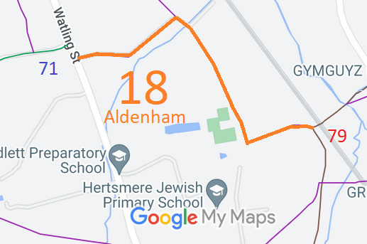
Map showing recorded Aldenham paths
Annotated map reproduced courtesy of Googlemaps.
This path starts on Watling Street (near Aldenham 71 bridleway) and continues generally north eastwards, southwards and eastwards to end on Aldenham 79 byway (Tykeswater Lane).

We need a volunteer to photograph this route for the Access and Rights of Way Survey. It's easy - just take photographs (safely) when you walk the path. Find out more!

BHS PGBT The Patchetts Green Bridleways Trust and the British Horse Society would like to see an upgrade of this path (or one close to it), since then the Aldenham Parish Ride could be split conveniently into two shorter routes.

Legal History
Definitive Statement (4 Dec 2015)
Path: [Aldenham] 18.  Recorded Status: Footpath.  Definitive Map sheet: 85
Commences from Watling Street thence E and NE passing to N of Kendal Wood thence SE along Eastern boundary of Wood thence E to junction with BOAT 79 Aldenham to the west of the Railway (TQ1751 9835).
Maintainability
This route is maintainable at the public expense because it was a footpath or bridleway existing before 30 Apr 1959.

© 2025 Patchetts Green Bridleways Trust. File reference: EC547.

Stats2