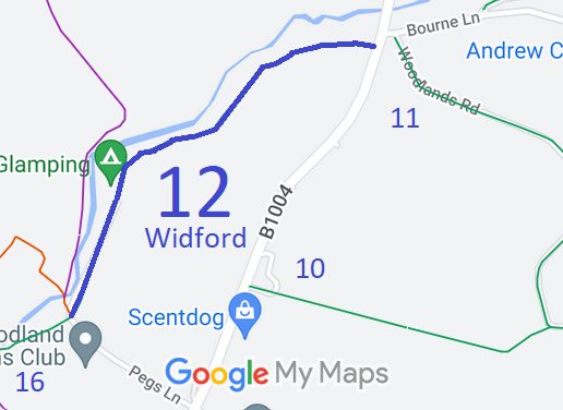
Annotated map reproduced courtesy of Googlemaps.
We need a volunteer to photograph this route for this year's Access and Riding Rights of Way Survey. It's easy - just take photographs (safely) when you use the path. Find out more!
| Paths Greenways Bridleways Tracks | ||
| PG: OBJECTS: PROMOTION: Widford 12 | ||
Annotated map reproduced courtesy of Googlemaps. |
This route starts on the B1004 (public road) not far from Bourne Lane and Widford 11 bridleway, and heads generally southwestwards to a junction of Peg's Lane (public road), Widford 16 bridleway and Widford 13 restricted byway.
We need a volunteer to photograph this route for this year's Access and Riding Rights of Way Survey. It's easy - just take photographs (safely) when you use the path. Find out more! |
| Legal History 1 Jul 2011: The Hertfordshire County Council (Widford 13, 18, 26 and Wareside 84) Modification Order 2011 (confirmed 14 Jun 2017) modified the definitive statement to record the junction with Widford 13 RB. |
Definitive Statement (9 Mar 2011)
Path: [Widford] 12. Status: Bridleway. Definitive Map sheet: 47 Commences from county road S of Hadham Mill opposite BR11 thence generally SW roughly parallel with River Ash to join RB13 and BR16 at county road, W of Bourne House (officially diverted in January 1953). |
© 2023 Patchetts Green Bridleways Trust.
