Legal History
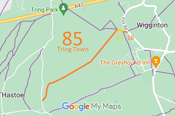
20 Jun 1953: Tring Town 21 was recorded as part footpath part CRF on the original definitive map and statement.
DM sheet DM3-10 (SP91SW). (The Icknield Way part was shown as CRF.)
20 Jun 1953: Tring Town 85 was not recorded on the original definitive map and statement.
DM sheet DM3-10 (SP91SW) and DM3-18 (SP90NW).
31 Dec 1977: Tring Town 21 was shown as a footpath on the special review draft map and statement.
DM sheet SR-51 (SP91SW).
31 Dec 1977: Tring Town 85 was not shown on the special review draft map and statement.
DM sheet SR-51 (SP91SW) and SR-63 (SP90NW).
18 Feb 2000: The King Charles Ride Dedication Agreement came into force.
14 Jul 2000: The Hertfordshire County Council (Tring Town 85) Legal Event Modification Order 2000 added the King Charles Ride footpath to the definitive map and statement.
28 Dec 2024: Tring Town 85: Main landholding: INSPIRE 48551466, HD323544, Dacorum Borough Council. Tenant: Woodland Trust.
|
|
Definitive Statement (4 Dec 2015)
Path: [Tring Town] 85. Recorded Status: Footpath.
Definitive Map sheets: 51 and 63
Commences from County Road Marlin Hill at SP9232 0958 thence north and north-
eastwards through Bishop's Wood for approx. 300 metres to SP 9246 0983, north-eastwards
for approx. 740 metres through Tring Park to SP 9307 1023, through Bulls Wood for approx.
410 metres to a junction with FPs 21 and 22 Tring at SP 9332 1056.
Width: 2 metres.
Limitations: Kissing Gate or Bollards at SP 9232 0958
Kissing Gate or Bollards at SP 9332 1056.
Path: [Tring Town] 21. Recorded Status: Footpath.
Definitive Map sheet: 51
Commences from urban district boundary W of Fox Cottage thence W through Park Wood to
junction with FP22 thence W to edge of wood thence NW across Tring Park to By-pass.
Path: [Wigginton] 18. Recorded Status: Footpath.
Definitive Map sheet: 51
Commences at junction with county road opposite Fox Cottages thence W to parish boundary.
Statement should refer to junction with Tring Town 21 at parish boundary.
|
Maintainability
Tring Town 21 is maintainable at the public expense because it was a footpath or bridleway existing before 30 Apr 1959.
|
|