Paths Greenways Bridleways Tracks
 PG: OBJECTS: PROMOTION: St Stephen proposed new route M001 (as part of Railfreight changes)  CMP6 
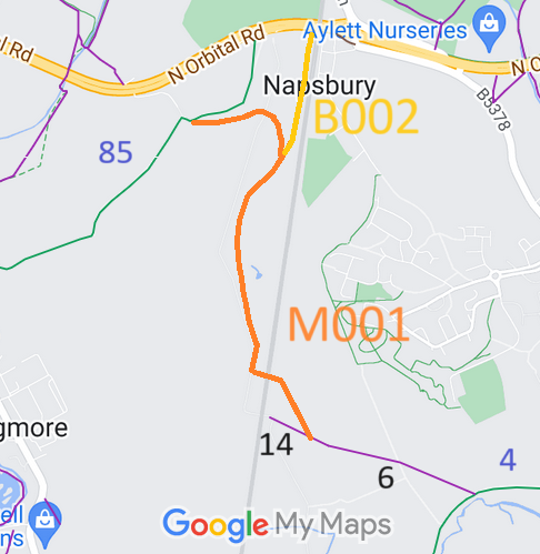
Map showing recorded St Stephen paths
Annotated map reproduced courtesy of Googlemaps.
The proposed route will start from London Colney 6 FP (which also needs upgrading to link to London Colney 4 bridleway) and continue generally northwestwards under the new (Dec 2024) railway bridge then turn generally northwards. At the junction with proposed bridleway B002, this route turns generally westwards to continue to St Stephen 85 bridleway.

Recording notes: Part of M001 will replace St Stephen 14 footpath.

Legal History
2 Oct 2024: The St Albans City and District Council Council (St Stephen 14) Diversion Order 2024, confirmed 9 Jan 2025, diverted St Stephen 14 footpath slightly to the north to become part of the route shown as 'M001' on the diagram above, as part of the Strategic Rail Freight Interchange. HCC reference STA/191.
31 Dec 2024: The physical underbridge of the Midland Mainline Railway was created during the railway's Christmas closure.
Definitive Statement (4 Dec 2015)
Path: [St Stephen] 14.  Current Status: Footpath.  Definitive Map sheet: 77
Commences at E side of railway thence SE to Parish boundary (London Colney).

Statement could usefully reference junction with London Colney 6 at parish boundary. Statement has yet to reflect the 2024 diversion order.

Path: [London Colney] 6.  Current Status: Footpath.  Definitive Map sheet: 77
Commences from BR4 S of Napsbury Hospital thence NW to parish boundary E of railway.

Statement could usefully reference junction with St Stephen 14 at parish boundary.

Maintainability
This route is maintainable at the public expense because it was a footpath or bridleway existing before 30 Apr 1959.

© 2024 Patchetts Green Bridleways Trust. File reference: ED124. HCC reference: STA/191.

Stats2