Patchetts Green Bridleways Trust
 PG: OBJECTS: PROMOTION: St Stephen: Featherbed Lane (West)
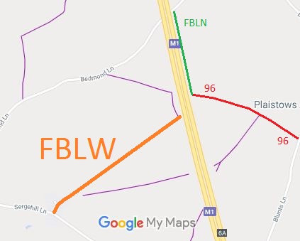
Map showing St Stephen 96 byway Featherbed Lane
Annotated map reproduced courtesy of Googlemaps.
Featherbed Lane is an old road which was severed by the M1 motorway. This section is on the western side of the M1 motorway. It starts on Sergehill Lane and heads generally notheastwards to stop at the boundary of the motorway and junction with a footpath, and so it is a cul-de-sac for riders.

The section on the eastern side of the motorway has been recorded as byway St Stephen 96.

BHS PGBT This route was identified as not recorded on the definitive map when members of the Patchetts Green Riding Club surveyed the riding routes in the area as part of the British Horse Socety's Access and Riding Rights of Way survey in 1991. An application was made in 1997 to record the route and it remains in the prioritised queue held by the county council.

Legal History
26 Oct 1973: London Gazette announcement that Hertfordshire County Council intends to apply to the Magistrates on 5 Dec 1973 to stop up this route.
24 Apr 1975: London Gazette announcement that Hertfordshire County Council intends to apply to the Magistrates on 3 Jun 1975 to stop up this route reserving bridleway rights.
1 Feb 1997: Definitive Map Modification Order application made to record the route. HCC reference STA/59.
16 Aug 2021: HCC investigate OSS application to add land to the Commons Register. The application plan shows part of Featherbed Lane within the application land. HCC reference CLP055A.
Application Process
Path Application Certificate Direction Inv Report Order Confirmed
EC157 1 Feb 1997 STA/59 26 Apr 2010        
 Definitive Map sheet: 76
Maintainability
This route is maintainable at the public expense because it was a highway before 1835.

© 2025 Patchetts Green Bridleways Trust. File reference EC157. HCC reference: STA/59.

Stats2