| Paths Greenways Bridleways Tracks | ||
| PG: OBJECTS: PROMOTION: St Stephen proposed new route B006 (as part of Railfreight changes) | CMP6 | |
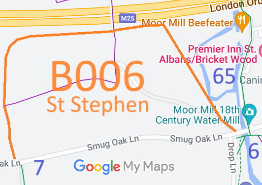
![]() Annotated map reproduced courtesy of Googlemaps. |
The proposed route would start on Smug Oak Lane, opposite St Stephen 7 BW and proposed route B007. It will continue northwards towards the M25 motorway, turn eastwards past the end of the motorway footbridge then turn generally southwards to meet Smug Oak Lane again close to St Stephen 65 BW, St Stephen 6 BW and Drop Lane.
When eventually the footbridge over the M25 has to be replaced, it is hoped that it will be put in at bridleway standard to link proposed bridleway B006 to proposed bridleway B005. Recording notes: Parts of B006 are currently recorded as St Stephen 33 footpath and St Stephen 35 footpath. |
|||
| Legal History |
Definitive Statement (4 Dec 2015)
Path: [St Stephen] 33. Current Status: Footpath. Definitive Map sheets: 76 Commences at junction with Smug Oak Lane opposite BR7 thence N to Grid Ref: TL1456 0230 and thence generally eastwards to Grid Ref: TL1479 0235 thence northwards to Grid Ref: TL1478 0245 to junction with FP35 and northwards across the M25 Motorway to Grid Ref: TL1477 0252 and junction with FP35a, thence westwards beside the Motorway boundary to Grid Ref: TL1467 0251 and north-westwards to Grid Ref: TL1460 0265 thence NW around perimeter of gravel workings to eastern boundary of railway thence NE along same to junction with Hyde Lane Path: [St Stephen] 35. Current Status: Footpath.
Definitive Map sheets: 76 and 77 |
© 2023 Patchetts Green Bridleways Trust.