| Patchetts Green Bridleways Trust | ||
| PG: OBJECTS: PROMOTION: St Stephen 8 BW | ||
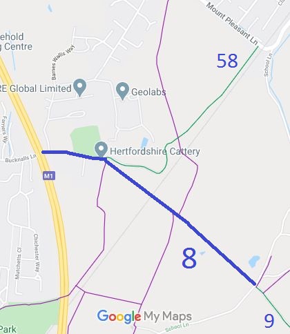
![]() Annotated map reproduced courtesy of Googlemaps. |
This route starts on the Watford boundary at Bucknalls Lane (public road) and follows a well defined route to a junction with St Stephen 58 BW then heads over a railway bridge through Bricket Wood to School Lane, opposite St Stephen 9. It is currently recorded as a bridleway.
We need a volunteer to photograph this route for this year's Access and Riding Rights of Way Survey. It's easy - just take photographs (safely) when you use the path. Find out more! |

|||
As part of the Patchetts Green Bridleways Trust's and British Horse Society's work to record paths before
Path Extinguishment Day,
it was spotted that there is historical evidence showing that this route is actually a road, Bucknalls Lane, and so carries rights for horse drawn vehicles. An application was made in 2018 to record the extra status and the width.
| ||||
| Legal History The route was recorded as a bridleway on the original (1953) definitive map and statement. DM sheet DM3-30. The route was recorded as a bridleway on the special review (1977) draft map and statement. DM sheet SR-76. 30 Oct 2018: Application for restricted byway status. HCC reference STA/166. |
Definitive Statement (4 Dec 2015)
Path: [St Stephen] 8. Status: Bridleway Definitive Map sheet: 76 Commences at end of county road (Bucknalls Lane) at Parish boundary thence E past Building Research Station to junction with BR58 thence SE across railway past FP's 48 and 59 through Bricket Wood Common to junction with county road (School Lane) W of Little Meadow Farm. |
© 2024 Patchetts Green Bridleways Trust.