Patchetts Green Bridleways Trust
 PG: OBJECTS: PROMOTION: South Mimms 77 RB Arkley Lane
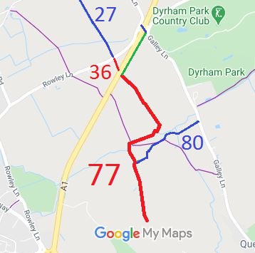
Map showing South Mimms 77 restricted byway
Annotated map reproduced courtesy of Googlemaps.
This route is known as Arkley Lane. It is part of a route that, before the Barnet By-Pass was built, ran from Rowley Lane and Packhorse Lane to Arkley.

It now runs from the verge of the A1 (with a verge-side path linking to a bridleway bridge over the A1) generally southwards then westwards then southwards to a junction with South Mimms 80 bridleway, then continuing generally southwards to the county boundary where it continues as a restricted byway in the London Borough of Barnet. The part on the north side of the A1 is now Ridge 36 restricted byway. There is no crossing of the A1 here - use the verge to the bridleway bridge instead.

We need a volunteer to photograph this route for this year's Access and Riding Rights of Way Survey. It's easy - just take photographs (safely) when you use the path. Find out more!

Legal History
20 Jun 1953: This route was recorded as CRF (Carriage Road used as a Footpath) 8 and 9 Barnet on the original definitive map.
2 May 2006: Restricted Byway rights were confirmed or created on this path by virtue of ss 47 and 48 Countryside and Rights of Way Act 2000.
Definitive Statement (4 Dec 2015)
Path: [South Mimms] 77.  Status: RB.  Definitive Map sheet: 78
Starts at entrance to Woodlands Farm thence NW to Saffron Green where it meets FP78. Continues NE and NW to the A1 opposite Ridge 36.
Maintainability
This route is maintainable at the public expense by virtue of s.49(1) Countryside and Rights of Way Act 2000. [RB converted from RUPP]

© 2025 Patchetts Green Bridleways Trust.

Stats2