Legal History
16 Jul 1994: Application to record this bridleway.
30 Jun 2017: The Hertfordshire County Council (North Mymms 90, 91 and Ridge 44) Modification Order 2017 (confirmed 1 Sep 2017) added this path to the definitive map.
|
Definitive Statement (4 Dec 2015)
Path: [Ridge] 44. Status: Bridleway.
Definitive Map sheet: 78
Commences from Ridge 10 at TL 2141 0302 then runs N and NE along the headland for approx. 380m to join North Mymms 90 at TL 2162 0330 at parish boundary.
Width: 3 metres
Limitations: None
Path: [North Mymms] 90. Status: Bridleway.
Definitive Map sheet: 78
Commences from Ridge 44 at TL 2162 0330 then runs NE along the headland for approx. 105m to a junction with North Mymms 2 at TL 2171 0335.
Width: 3 metres
Limitations: None
|
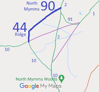

 This route was recorded as a result of user evidence collected.