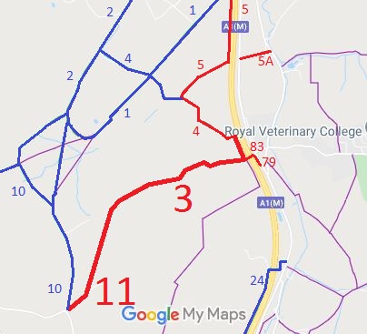
Annotated map reproduced courtesy of Googlemaps.
We need a volunteer to photograph this route for this year's Access and Riding Rights of Way Survey. It's easy - just take photographs (safely) when you use the path. Find out more!
| Patchetts Green Bridleways Trust | ||
| PG: OBJECTS: PROMOTION: Ridge 11 and North Mymms 3 RB | ||
Annotated map reproduced courtesy of Googlemaps. |
This path runs from Blackhorse Lane and a junction with bridleway Ridge 10 to a junction with restricted byway North Mymms 83 (which leads over the A1(M) motorway to Swanland Road) then turns alongside the A1(M) motorway to a junction with Love Lane (North Mymms 4).
We need a volunteer to photograph this route for this year's Access and Riding Rights of Way Survey. It's easy - just take photographs (safely) when you use the path. Find out more! |
| Legal History Ridge 11 and North Mymms 3 were recorded as CRBs (Carriage Roads used as Bridleways) on the original (1953) definitive map. Restricted Byway rights were confirmed or created on the route by virtue of ss 47 and 48 Countryside and Rights of Way Act 2000 on 2 May 2006. |
Definitive Statement (4 Dec 2015)
Path: [Ridge] 11. Status: Restricted Byway. Definitive Map sheet: 78 Commences at junction with county road and BR10 by lodge at S corner of Redwell Wood thence NE along parish boundary and into North Mimms parish. Path: [North Mymms] 3. Status: Restricted Byway.
Definitive Map sheet: 78 |
© 2021 Patchetts Green Bridleways Trust.