Paths Greenways Bridleways Tracks
 PG: OBJECTS: PROMOTION: Letchworth 1 BW and Wymondley 1 BW
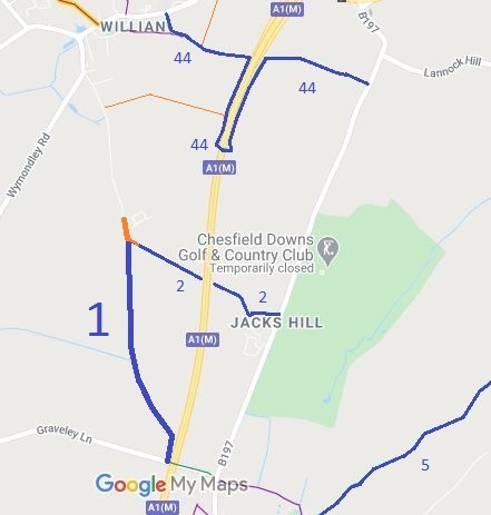
Map showing Letchworth 1 bridleway
Annotated map reproduced courtesy of Googlemaps.
This route runs from the end of Roxley Road and junction with Letchworth 2 bridleway generally southwards to Graveley Lane.

We need a volunteer to photograph this route for this year's Access and Riding Rights of Way Survey. It's easy - just take photographs (safely) when you use the path. Find out more!

BHS The short section shown in orange is open and available for use, but it was not clear that it was properly recorded. An application was made in 2014 in order to ensure it is safeguarded. On 25 May 2015, it was spotted that this route had been added to the County Council's List of Streets.

Legal History
1 Nov 1953: Letchworth 1 and Wymondley 1 were recorded as bridleways on the original definitive map and statement. DM sheet DM4-32 (Herts 12 NE).
7 Jun 2014: Application for the gap between Letchworth 1 and Roxley Court Road to be shown as a byway.
25 May 2015: Orange path was spotted on the County Council's List of Streets.
Definitive Statement (4 Dec 2015)
Path: [Letchworth Garden City] 1.  Status: Bridleway.  Definitive Map sheet: 21
Commences from end of Roxley Road SW of Roxley House thence S to parish boundary towards Graveley.
Width: 6 ft

Path: [Wymondley] 1.  Status: Bridleway.  Definitive Map sheet: 21
Commences from W end of Pinch Lane thence W under A1(M) and N and NW to northern parish boundary to join BR1 (Letchworth Garden City) S of Roxley Court.

© 2023 Patchetts Green Bridleways Trust. File reference: EC854.