Paths Greenways Bridleways Tracks
 PG: OBJECTS: PROMOTION: Langley 16
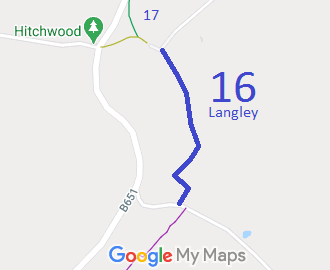
Map showing Langley 16 bridleway
Annotated map reproduced courtesy of Googlemaps.
This route runs from Hill Farm Lane (public road), near Langley 17 bridleway, generally southwards to Shilley Green Road (public road).

We need a volunteer to photograph this route for this year's Access and Riding Rights of Way Survey. It's easy - just take photographs (safely) when you use the path. Find out more!

Legal History
1938: The route is shown as a bridleway (blue dots) on the Hertfordshire County Council ROW survey. Map Hitchin Rural West 15 (Herts 20 NW).
1 Nov 1953: The route was recorded as a bridleway on the original definitive map and statement. DM sheet DM4-33, DM4-40.
31 Dec 1977: The route was shown as a footpath on the special review draft map and statement. Objections were made. DM sheet SR-28.
1988: The Hertfordshire County Council (Review of Definitive Map) Order 1988 downgraded the route to footpath, but this was on the basis of no objections to the Special Review, in error.
23 Jul 2004: The Hertfordshire County Council (Langley 16) Modification Order 2004 (confirmed 5 Jul 2012) recorded this route as a bridleway again. HCC Reference NH/132.
Definitive Statement (4 Dec 2015)
Path: [Langley] 16.  Status: Bridleway.  Definitive Map sheet: 28
Commences from right-angled bend in county road at Langley End TL 1986 2387, thence SE and S to join Shilley Green Road approx. 140 yards E of Langley - St Pauls Walden Road at TL 1992 2342.
Width: Varies between 3.5 and 7 metres
Maintenance
This route is maintainable at the public expense because it was a footpath or bridleway existing before 30 Apr 1959.

© 2024 Patchetts Green Bridleways Trust. File reference: EC344. HCC reference: NH/132.

Stats2