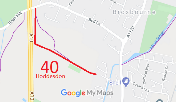
Annotated map reproduced courtesy of Googlemaps.
We need a volunteer to photograph this route for this year's Access and Riding Rights of Way Survey. It's easy - just take photographs (safely) when you use the path. Find out more!
| Paths Greenways Bridleways Tracks | ||
| PG: OBJECTS: PROMOTION: Hoddesdon 40 RB | ||
Annotated map reproduced courtesy of Googlemaps. |
This route runs from Baas Hill (public road) and runs generally south then southeastwards to end on Cozens Lane West (public road).
We need a volunteer to photograph this route for this year's Access and Riding Rights of Way Survey. It's easy - just take photographs (safely) when you use the path. Find out more! |
| Legal History 4 Jul 1890: The Broxbourne and Hoddesdon Open Spaces and Recreation Grounds Act 1890 declared and defined part of this route to be public carriageway. (Carriageway 5.) 12 Feb 1971: The London - Cambridge Trunk Road (Hoddesdon By-Pass, Side Roads) Order 1971 (which came into effect on 23 Feb 1971) diverted the route of Hoddesdon 40 CRF to the present alignment. 2 May 2006: Restricted Byway rights were confirmed or created on this path by virtue of ss 47 and 48 Countryside and Rights of Way Act 2000. |
Definitive Statement (4 Dec 2015)
Path: [Hoddesdon] 40. Status: Restricted Byway. Definitive Map sheet: 72 Commences from W end of Cozens Lane West. thence NW, S of Cozens Grove then N parallel with by-pass to Cock Lane - White Stubbs Lane. |
© 2022 Patchetts Green Bridleways Trust.
