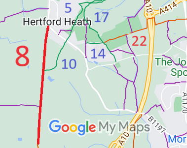
Annotated map reproduced courtesy of Googlemaps.
We need a volunteer to photograph this route for this year's Access and Riding Rights of Way Survey. It's easy - just take photographs (safely) when you use the path. Find out more!
| Paths Greenways Bridleways Tracks | ||
| PG: OBJECTS: PROMOTION: Hertford Heath 8 RB Elbow Lane (part of Ermine Street) | ||
| London Orbital Bridleroute: Anti-clockwise: Brickendon Liberty 24. Clockwise: Hertford Heath 10. | H25 | |
Annotated map reproduced courtesy of Googlemaps. |
This route starts from London Road (public road) and continues southwards along the line of Ermine Street (a Roman Road) to meet Brickendon Liberty 24 restricted byway at the parish boundary.
We need a volunteer to photograph this route for this year's Access and Riding Rights of Way Survey. It's easy - just take photographs (safely) when you use the path. Find out more! |
| Legal History 2 Feb 1953: Hertford Heath 8 was recorded as Brickendon Liberty 24 CRB (Carriage Road used as a Bridleway) and Great Amwell 7 CRB on the original definitive map and statement. DM sheet DM2-30 (Herts 36 NE). 1 Apr 1959: The parish boundary along which the route ran was moved into Little Amwell by the County of Hertford Parishes of Brickendon Liberty and Little Amwell Order 1958. 31 Dec 1977: Hertford Heath 8 was shown as Little Amwell 8 BOAT and Great Amwell 7 BOAT on the special review draft map and statement. DM sheet SR-60 (TL31SE). There must have been objections as the path remained shown as a RUPP (CRB) afterwards. 1 Apr 1990: The parish of Hertford Heath was created out of Little Amwell and parts of neighbouring parishes, resulting in some path number changes. 2 May 2006: Restricted Byway rights were confirmed or created on this path by virtue of ss 47 and 48 Countryside and Rights of Way Act 2000. |
Definitive Statement (4 Dec 2015)
Path: [Hertford Heath] 8. Status: Restricted Byway. Definitive Map sheet: 59 and 71 Commences at junction with Hertford - Hoddesdon road thence S along Elbow Lane past BR10 and FP7 (at TL 3481 0984) to parish boundary S of Elbow lane Farm. (former Little Amwell RUPP8 and Great Amwell RUPP7). |
© 2022 Patchetts Green Bridleways Trust.
