Paths Greenways Bridleways Tracks
 PG: OBJECTS: PROMOTION: Hemel Hempstead Pulleys Lane
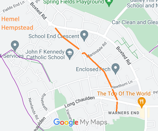
Map showing recorded Hemel Hempstead paths
Annotated map reproduced courtesy of Googlemaps.
This route startes from Boxted Road (public road) and continues generally southeastwards and southwards to end on Parkwood Drive (public road).

A volunteer has photographed this route for the 2025 Access and Riding Rights of Way Survey, and the page will be updated shortly. Find out more!

At the time of the 2025 Access Survey (2 Jan 25), no gates were across the path and it was signposted 'Pulley's Lane' at various points. There were no obstructions to access, but a little deviation from the straight line route was needed at some road crossings. The route remained usable.

Legal History
1843: This route was shown on the Hemel Hempstead tithe map as not subject to an apportionment.
1910: This route was shown unvalued on the Inland Revenue Valuation Maps.
20 Jun 1953: The route was not recorded on the original definitive map and statement. DM sheet DM3-20.
31 Dec 1977: The route was not shown on the special review draft map and statement. DM sheet SR-65.
2 May 2006: NERC exemption s.67(2)(b) as route not on DM but was on LOS.
12 Oct 2024: Application for byway. HCC reference DAC/182.
Application Process
Path Application Certificate Direction Inv Report Order Confirmed
EC1233 12 Oct 2024 DAC 4 Jan 2025        
[This route is not yet recorded and so there is no definitive statement.]
Maintainability
This route is maintainable at the public expense because it was a highway before 1835.
Location Information
Postcode for SATNAV for anyone inspecting path: HP1 2QP.

© 2024 Patchetts Green Bridleways Trust. File reference: EC1233. DOBBIN reference: HER-0170. HCC reference: DAC/182.

Stats2