Paths Greenways Bridleways Tracks
 PG: OBJECTS: PROMOTION: Hemel Hempstead 44 RB
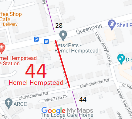
Map showing recorded Hemel Hempstead paths
Annotated map reproduced courtesy of Googlemaps.
This restricted byway runs from Queensway (public road) to Christchurch Road (public road). A path of the same number continues southwards as a footpath to Broad Street,

A volunteer has photographed this route for the 2023 Access and Riding Rights of Way Survey, and the page will be updated shortly. Find out more!

Legal History
20 Jun 1953: The whole route was recorded as a footpath on the original definitive map and as part CRB and part FP on the statement. DM sheet DM3-21 (Herts 33 NE /TL00NE).
31 Dec 1977: The route was shown as part byway part footpath on the special review draft map, but the byway is omitted and the remainder shown as footpath on the statement. DM sheet SR-66 (TL00NE).
1 Mar 2002: The route was shown as part RUPP part footpath on the definitive map and footpath on the definitive statement. This suggests that there must have been a objection at the special review.
2 May 2006: Restricted Byway rights were confirmed or created on the part shown as RUPP path by virtue of ss 47 and 48 Countryside and Rights of Way Act 2000.
Definitive Statement (4 Dec 2015)
Path: [Hemel Hempstead] 44.  Recorded Status: Footpath.  Definitive Map sheet: 66
Starts in Queen Street at side of the White Lion P.H. to Christchurch Road. From Christchurch Road to Broad Street as a FP.

Discrepancy in status between map (shows as RB and FP) and statement (shows as FP but wording of statement implies that it changes part way along).

Maintainability
This route is maintainable at the public expense by virtue of para 7 of Sch 3 to the Countryside Act 1968. [Converted from RUPP]
Location Information
Postcode for SATNAV for anyone inspecting path: HP2 5BX.

© 2024 Patchetts Green Bridleways Trust.

Stats2