Paths Greenways Bridleways Tracks
 PG: OBJECTS: PROMOTION: Hemel Hempstead 23
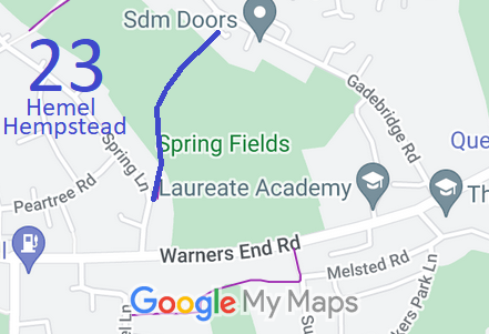
Map showing recorded Hemel Hempstead paths
Annotated map reproduced courtesy of Googlemaps.
This route runs from Spring Lane via Saffron Lane to Gadebridge Road.

A volunteer has photographed this route for this year's Access and Riding Rights of Way Survey, and the page will be updated shortly. Find out more!

At the time of the 2024 Access Survey (3 Nov 24), the path was unobstructed, although the section between houses at the NE end had a height restriction. The path was difficult to follow for anyone without a map although the start and end points are clear. There was no council signposting or waymarking at all.

Legal History
20 Jun 1953: The route was recorded as a bridleway on the original definitive map and statement. DM sheet DM3-20 (TL00NW; Herts 33 NE).
18 Jul 1975: The Dacorum District Council (Bridleway 23 (Warners End)) Public Path Extinguishment Order 1975 was made. It is unknown whether it was confirmed.
25 Jul 1975: London Gazette announcement of making the order. No notice of confirmation has been located.
31 Dec 1977: A slightly shorter route than in 1953 was shown as a bridleway on the special review draft map and statement. DM sheet SR-65 (TL00NW).
15 Aug 2022: Spotted that route shown on map as FP but in statement as BW. Made enquiries of HCC.
17 Aug 2022: Asked Dacorum Borough Council for copy of 1975 order.
17 Jul 2023: Dacorum Borough Council unable to locate any copy of the 1975 order.
15 Oct 2024: Application to record as bridleway. HCC reference DAC/184.
3 Nov 2024: Reported no signpost where path met metalled road (either end) to HCC. References: 401004418693 and 401004418695.
Application Process
Path Application Certificate Direction Inv Report Order Confirmed
EC1176 15 Oct 2024 DAC/184 8 Nov 2024        
Definitive Statement (4 Dec 2015)
Path: [Hemel Hempstead] 23.  Status: Bridleway  Definitive Map sheet: 65
Commences from Spring Lane adjacent to house No. 16 thence N and NE between No's 8 and 9 Saffron Lane to join Gadebridge Road.

Map shows FP, statement shows BW.

Maintainability
This route is maintainable at the public expense because it was a footpath or bridleway existing before 30 Apr 1959.
Location Information
Postcode for SATNAV for anyone inspecting path: HP1 3QH.

© 2024 Patchetts Green Bridleways Trust. File reference: EC1176. DOBBIN reference: HER-0169 and HER-0173. HCC reference: DAC/184.

Stats2